Monday, October 6, 2014

Day 2-323 to Clifton's City Marina, TN

     Oh, you know that it's trouble when the first picture of the post is a sunrise picture... We left the dock at 6:47 am, and headed south up Kentucky Lake. For the departure the Admiral took the helm, and a few minutes later we were safely out in the channel. It was amazing as there was no yelling (by me), no screaming (by me). I will have to be careful as she might get to like this. Then I would have to pull up the fenders, hang the lines, cover the electric cords, etc. Is this pay back time? Anyway, I am getting the point that she does do a LOT of work before and after docking...

     Out on Kentucky Lake (Tennessee River) we were greeted by a now familiar sight. At least this time it was only small patches of fog (picture at left). Our trip for the day was 62.9 miles (about 8 hours), which was the reason for the early start since we would also be slowed a few tenths of a mph due to current. In fact the start was so early that I got to eat breakfast after we had gotten underway... Well, there was some payback later in the morning when I got to take a nap before lunch (Thanks Admiral!).

     We had a total of four bridges to go under today. There were three fixed bridges with a clearance of 60.4 feet or more. However, the first bridge was a lift bridge for the Louisville & Nashville Rail Road.  It had a clearance of 24.5 feet so we did not need to have it raised to go under. We have gone under or through many rail road bridges, but this was one of the few where we actually saw a train go over the bridge (picture at right). The whole bridge was over a mile long over the lake so the whole view  of the train and bridge was pretty neat. The picture shows several of the engines on the central lift span. The grey band across the picture behind the bridge is the Hickman-Lockhart (traffic) bridge just a few hundred feet to the south. For you history buffs and fans of movie star Gary Cooper, the last bridge of the day was the Alvin C. York Bridge. It was named in honor of the famous World War I Medal of Honor Winner who was a native of Tennessee.
     The scenery along the lake was often quite good with steep rock faces along the shore and some Fall colors.

We arrived at the marina and after checking in, I managed to sneak in a short nap even though it was after the Admiral's Official Deadline to start a nap (no later than 3:30 pm). There were not a lot of options for eating dinner out so we had very good hamburgers in the grill at the marina office.

Another nice but long day on the water, but there are changes ahead...

Sunday, October 5, 2014

Day 2-322 to Pebble Isle Marina, New Johnsonville, TN

     We left Paris Landing Marina at the crack of 8:47 am to head up (south) on Kentucky Lake for 31.6 miles to Pebble Isle Marina near New Johnsonville, TN. The picture at the right was our view back at Paris Landing Marina as we left. Looks like a beautiful day?


     Taking a picture out over the bow of Lucky Us gives a completely different take on the weather. Cool air and warm water is ideal for the formation of fog. Since we had a relatively short trip of about 4 hours, we had delayed our start to let the fog begin to burn off. The channel out of the marina parallels the bridge until the center span where we turned to starboard (right) to continue south. By now we have a fair amount of experience in fog, and we had the radar running although we only had it displayed on the screen of the chart plotter a couple of times in thicker patches of fog.
     Kentucky Lake is about 2 miles wide in this area, and the ship channel was sometimes about half that wide. We did go close to shore several times, and we saw many nice bays and lots of pretty (sometimes rocky) shoreline. September has been a very dry month here this year so most of the fall colors that we have seen is probably due to vegetation drying out.
     We only saw two tows (tow boats with barges) on the lake today, but we did see some other "interesting" sights. One of those sights was this railroad bridge to nowhere (picture at left). If you look at the left side of the picture, the bridge just ends after the second span. I suppose that they are waiting for it to fall down before they remove it...
     Another strange sight was this three story warehouse (?) structure about a quarter of a mile from shore. Kentucky Lake is at least 80 years old so perhaps they raised the top of the dam at some point?

     Certainly one of the best views of the day was this flight of white pelicans that flew right in front of Lucky Us. We see lots of water birds, but usually when we scare them into flight, they fly away from us.

     We arrived at Pebble Isle Marina about 1:00 pm (picture at right). The marina was typical of the ones in this area with covered slips for almost all of the yearly rentals, and we were docked along side a fairly long pier for transients.  After checking in, it was (are you ready for this?) nap time. The couple that ran the marina were really very nice, and they tried to lure us to wait in the morning to partake of fresh, home made cinnamon rolls, but we kept declining as politely as possible. We often eat out once a day, but otherwise, we try to eat pretty healthy. The rolls sounded very appealing, but...
     We had reserved the marina courtesy van for 5:00 pm. First, we went about 10 miles to a Walmart in New Waverly, TN for some "supplies". Then we went back to Lucky Us to unload and check with another couple who had indicated that they "might" want to go along to dinner. Well, that did not happen so we headed out 12 miles north to Camden to a Mexican restaurant that the marina had recommended. Wow, that was the best Mexican food that we had tasted since we left Texas. I had Enchiladas Verdes while the Admiral had Tacos Mexicano (4 small tacos with different fillings). It was a long (sleepy) drive back to the marina, but the meal was definitely well worth the drive!
     From New Johnsonville as we continue to head south (up river) we will no longer be in Kentucky Lake but rather in a wide flooded (Tennessee River) river valley. Thus, our "road" will be narrower until we reach the Pickwick Landing Dam and Lock in several days.

Saturday, October 4, 2014

Day 2-321 to Paris Landing State Park Marina

     We departed Kenlake Marina about 9:30 am headed up the lake about 25.2 miles to Paris Landing. We arrived about 1:00 pm and checked in after securing Lucky Us alongside the transient dock. A few minutes later we notice a LOT of bass boats heading into the marina. It turns out that there was a Toyota Truck Owners Bass Tournament that was in the process of ending. There was a staggered check in at 2:00 and 2:30 pm.

      The boats entered the harbor and headed to the first dock where they tossed their tracking chip into a fish net. The man holding the net then passed the chip off to someone to scan the chip. Officials on the dock handed each boat two bags. There were some professional fishermen that were sponsored by Toyota, but most of the teams were amateurs. The mix of anglers included couples, parents and children, friends, etc.

     The fish were first put into a net bag, which was then put into a larger bag with water in it to keep the fish alive. The picture at the right shows the boat just off our stern. They had three live wells with fish in each. They are carefully putting a fish into a bag in the picture. Once the bags were loaded, it was off the dock to the check in area where they had a stage, tables, chairs and food (for the contestants). There were lots of ESPN logos as well as Toyota, but we did not manage to "get on TV'.

      The announcer was quite professional and trying his best, but most of the anglers had less than the 5 fish limit. In the picture at the left one team member is showing off two of their bass, while the man in the left is holding the "water bag". The fish were all weighed in the net bags and then put back in the water bag. The fish must be alive to be counted, and then they are put into a big tank to be returned to the lake. They were serious fishermen, but the rules also included catch and release.
     We did not stay very long since it was hot in the sun, but the fish in the picture at the right was the top fish in the running for the biggest (single) fish of the day. It was 5 pounds 6 ounces, but there were many more teams to check in yet.


     The picture at the left shows me (on the right) chatting with one of the locals. Everyone was having a good time, and many of the participants had families greet them at the dock. There were cash prizes for the top 30 teams as well as random cash drawings for the teams outside the money.


     When we got back to Lucky Us, it was nap time, and when I got up, all of the boats had been loaded and were gone. It was back to being a rather quiet setting along the docks.


     We did not pass under any bridges or go through any locks today, but the marina is adjacent to the Ned R. McWherter Bridge across Kentucky Lake. For dinner we walked out along the edge of the campground to the main road. After crossing the main road we followed a lovely drive about a quarter mile to the Paris Landing Lodge and Convention Center. The lodge is in a beautiful setting perhaps a 100 feet above the lake. I did not get any pictures since by then it was getting pretty dark especially with all of the big trees (my weak excuse). We had a nice view from our table, and we tried to restrain ourselves at the very good buffet. I was doing a good job until I hit the desserts...

Friday, October 3, 2014

Day 2-320 off early to Kenlake Marina in time to watch Aggie Football

     After our strenuous day and late night last night, we had a more leisurely start today as we left the dock about 9:45 am and headed to the fuel dock for a pump out. The picture at the right looks back toward the fuel dock as we are leaving Green Turtle Bay Marina after the pump out. As you can see by the small ripples on the water and the blue sky, the weather was near perfect, except that it was going to get hot in the sun.

     One of our final views of the marina was of these condominiums. Aside from all of the work on the house battery bank and the inverter, our experience at Green Turtle Bay was quite pleasant. If we had not already made reservations ahead, I am sure that we would have gladly stayed here longer. One of the reasons that some people do a second trip around the Great Loop is that you miss some stops and do not get to stay long enough at other stops. I am beginning to see why people feel that way.


     We exited the marina into Barkley Lake on the Cumberland River and headed south or up river. After about a half mile we turned to starboard to enter the Barkley Canal that connects Barkley Lake on the Tennessee River with Kentucky Lake on the Tennessee River. Both rivers drain different areas so at any one time one lake may be receiving more water from upstream. The Corps of Engineers can adjust the discharge at the dams to account for most of this difference, but on our trip through the Barkley Canal we went into a current of about 1.5 mph. The canal is only about 2 miles long with two high bridges, but for pleasure boaters it is a bonanza since it connects two large lakes for access without having to trailer your boat between the two lakes.
      We are heading to Kentucky Lake because we are going to be going further up the Tennessee River.  As we exited the Barkley Canal into Kentucky Lake, we had a view of Kentucky Dam several miles away to the north. In the picture at the right the lock is in the middle with the dam going off to the left (west). Beyond the dam the top of a bridge is visible as well as three groups of towers for electricity transmission. On the right center there are several barges and tall yellow cranes. Both the Barkley and Kentucky Locks have only one lock chamber. If you remember back several days, we had bypassed this lock due to the delays due to lots of commercial traffic. The barges and construction cranes represent construction of a second smaller or auxiliary lock here. This auxiliary lock will handle small tows, towboats with no barges and pleasure craft. Thus, this new lock will hopefully greatly reduce transit times for all parties.
      Even though it was a Saturday with perfect weather, there were not many pleasure craft out on the lake. However, we did see what appeared to be a fleet of sailboats racing. At this point we had about 15 miles to go to our destination. When we turned south to head up the lake, we had a head current of about 1 mph, which was probably due to our proximity to the dam. As we proceeded up the lake the current diminished to about 0.3 mph (or less?) at out destination.
    As we approached our destination of Kenlake Marina, we also got better views of the shoreline. The remainder of the trip was uneventful, and we were docked and ready to watch the Aggies  BTHO Arkansas on TV. The score was tied at 7-7 at the end of the first quarter when the Admiral's cell phone rang. What a pleasant surprise! It was the Grandkids (with a little help from their Father) who had called to say hello during the intermission. Then the Admiral cooked up some pop corn and we were ready to go...

    It took a while, but the Aggies did win by 6 points in overtime... WHOOP! Another perfect ending to a day on the water.

Days 2-317 to 319 at Green Turtle Bay Marina

     After about 300 miles in three long days, we were definitely ready for some down time! We are at Green Turtle Bay Marina, which is a favorite among Loopers. The marina is mainly covered slips, but most of the transient boats are put in the less desirable open slips. Luckily for us, Lucky Us (sounds like some kind of funky play on words) was soooo big that they decided to put us in a covered slip. We docked with the bow pointed into the slip, which means that the stern, which is barely under the "roof",  is pointed more or less due south.  Therefore, we can put the satellite dish on the aft end of the flybridge, and in that location the dish should have an unobstructed view toward the appropriate satellite... Nothing like planning ahead!
     The picture at the left gives a partial overview of this huge complex. There is a sailboat dock (uncovered) on the right. At the far end of the sailboat dock is the (elevated) private yacht club where transients are "Temporary Members". Above the sailboats in the hillside is a row of one bedroom condos, and above them and scattered elsewhere are detached 2 story condo town houses. In the center you can see the sterns of about seven boats, and behind them is the office, bathrooms and laundry. Toward the left is a row of low buildings that house the marine store and several repair shops. This is one of the more complete full service marinas for many miles around. They also have a fitness center with an indoor pool, exercise room and spa. I am sure that I have missed a few things, but maybe you can begin to see why this is such a popular stop for Loopers.

      As we came up the Ohio River yesterday, we had the choice of two rivers to enter. The Cumberland and Tennessee Rivers enter the Ohio River 11.8 miles apart, but each has a lock and dam slightly up river. It turns out that the Kentucky Dam (Tennessee River) is only 2 miles in a straight line  from the Barkley Dam on the Cumberland River. On Day 2-316 we made the decision to take the longer route via the Cumberland River, since we knew that we would have had a minimum of a 2.5 hour wait for a lock through on the Tennessee River at the Kentucky Lock and Dam. Also, the lakes behind each dam are at (more or less) the same level so they are connected by Barkley Canal, which we will go through later on Day 2-320, since ultimately we want to go up the Tennessee River.

Day 2-317 First full day at Green Turtle Bay Marina
     We both slept (on/off) for nearly 12 hours! Whew! It was a sure sign that it had been a tiring trip the past 3 days when even the Admiral could sleep in so long. We headed to "Dockers", which was the café practically at the end of our covered pier. It is only open for breakfast and lunch, which seems to be typical of many small cafes lately. We both had salads, and of course, mine was a Caesar with grilled chicken. The Admiral had mixed green salad with grilled chicken and blue cheese dressing. After lunch we made reservations for a van from Patti's Restaurant to pick us up for dinner. Patti's is an 1880's style restored village built around the restaurant a little over a mile from the marina. Fortunately (?), the shops in the village were all closed when we arrived for dinner. It turned out that the driver was also a porter at the restaurant. They obviously get a lot of business from the marina and are quite accommodating. The restaurant had a number of rooms along with a large foyer. All were done in rough cut cedar, and they were all very heavily decorated. The foyer and one large dining room were already done for Christmas, and evidently they start this process as early as the first of August. There are ads on signs inviting people to the Lighting Celebration at the beginning of November. We ate in a dining room that was about 30 feet square, and the main theme was large (from 6 inches to over a foot) cloth and paper roses that were strung in a vine like network all over the room. Like I said, the decorations were really intense and almost overpowering. The Admiral had the thinner version of the house specialty two inch pork chop. I had a very tasty pork tenderloin. The food was really good, and we shared a dessert as if we were not already stuffed. We got back to Lucky Us about 8:30 pm and tried to stay awake for an hour before going to bed.

Day 2-318 Second full day at Green Turtle Bay Marina
     In the morning we took the marina courtesy van to Paducah, Kentucky about 25 miles away. The picture at the right shows the sign at the marina entrance. ...and yes we did see turtles on logs and rock sunning themselves. Our main goal was to purchase a new inverter for the house battery bank. This battery bank is what powers all of the 12 volt DC equipment on the boat, We also attach two inverters to it to convert 12 volt DC into 110 volt AC power. We use the smaller one of the inverters to power electronics like wifi, printer, TV, satellite dish, etc. This inverter produces current that is in the shape of a sign wave, which is the same as the power you get in your home/office. The inverter that we replaced has a much higher output (2,000 watts) but produces what is called a modified sine wave, which is really a "square" wave. It is perfectly acceptable to power AC motors like those in refrigerators as well as other appliances such as the coffee maker and the induction cooker. This is the inverter that we use whenever we are away from the dock to power the refrigerator. Without the inverters we would have to run the generator virtually all of the time that we are away from the dock. Running the generator is both expensive since it uses about 1 gallon of diesel fuel per hour, but the engine is also noisy.  It is also essential when we anchor out over night and do not want to run the generator. This system had not been performing at all well. There could only be two problems, which means either a bad inverter or a bad bank of batteries. We got back to the boat and installed the new inverter. It performed better than the old one, and the 110 volt Ac power output lasted longer than before. However, the battery bank is very powerful, and we should be able to run the refrigerator alone for perhaps 48+ hours without recharging the batteries. At this point, all evidence pointed to bad batteries. More to check tomorrow...
     While we were using the courtesy van, we also got groceries, and returned to the marina within the 2 hour time limit for the van. We had a leisurely lunch on board Lucky Us. By then it was nap time for me, and the Admiral headed off in time for an appointment for a pedicure and manicure at the spa. Duly pampered, we spent the rest of the day on the boat and even managed to stay awake until the 10 o'clock news...

Day 2-319 Third (and last) full day at Green Turtle Bay Marina
     The Admiral has been continuing her early morning walks, and she has seen quite a few deer on the marina property around sunrise (picture at left).
     I rode my electric bike over to see the marina service manager about 11:00 am. I had done all of the tests that I could do on the battery bank using our multimeter. The next step was to check each individual battery using a "load tester".  The service manager was very accommodating and insisted that he would personally come to the boat and do the tests. We arranged to meet at Lucky Us at 1:30 pm, as the Admiral was just arriving on her bike so that we could ride into town for lunch. We first went to the grocery store, which had just (today) re-opened after a 6 week renovation. One thing that they added was a café run from the deli counter. So, for lunch we had very good sandwiches made to order. We headed back to Lucky Us with a good sized load of groceries and full stomachs.
      The service manager was polite enough to call and say he would be 20 minutes late, but we were soon gathered around the batteries in the engine room. The load tester puts a load (i.e. draws power) on the battery for a few seconds and checks how the battery responds. The load lowers the voltage in the battery, but it should "bounce back" quickly to its original voltage. Of the 5 batteries one passed, one was marginal and three failed the test. This is good news, except these marine deep discharge batteries are more expensive than your normal car starting battery, of course.
     Fortunately, we had already reserved the courtesy van for a four hour period so that we could go to Paducah to see the movie "The Maze Runner". First we had to get the batteries up out of the engine room and off the boat. Then we loaded them onto a cart for the trip to shore. As if we had not worked hard enough already, the ramp from the dock to land was about 150 feet long and went up over 30 feet. Even taking just 2 batteries at a time, it was hard work pulling the cart up the ramp in the hot sun! After loading the batteries into the van, it was time to head to Paducah to see the movie and enjoy the popcorn. Then it was off to buy new batteries.
    We got back to the marina about 8:00 pm, and we had to reverse the process of getting the batteries back down into their battery box in the engine room. UGH! In out grand plan of things tomorrow is Saturday, and we had already made reservations at another marina only 20.5 miles away. Normally, we would have installed the batteries in the morning before we left on the short 2.5 hour trip. Unfortunately, we could not do that since we had to be all settled into the marina before the Aggie football game at 2:00 pm. So, we really needed to install the batteries that evening. It was hard physical work lifting the 60 pound batteries, etc. Then we had to reconnect all of the batteries to each other as well as to the boat, the two inverters and the battery charger. That amounts to a total of 38 different ends of wires. After checking all of the connections to make sure that we had all the pluses and minuses correct, we turned on the system and tested everything. So far so good, but now we would not know for sure until all of the batteries were fully charged over night. I turned on the battery charger, and we had to wait until the morning to see if we had actually fixed the system. Of course, by the time we finished the work it was 10:30 pm, and we were both very tired! Our 3 days at Green Turtle Bay were nice, but obviously, they were nowhere near as relaxing as we had planned...

Thursday, October 2, 2014

Day 2-316 cruising up the Ohio to the Cumberland River

     Cruising on the river system has been wonderful, BUT I am getting a little tired of seeing sunrises over XYZ River. The picture at the right is, you guessed it, sunrise over the Ohio River as we were raising the anchor at 6:35 am. The view is toward the Kentucky side of the river (southeast) with Illinois on the side behind the camera. The overnight temperature went into the lower 60s F so we slept well without air conditioning. Our trip for the day was only 75 miles, but most of the trip was going up river into a 2+/- mph current so we knew that it would be a long day.

     During the night, there was a big hatch of May Flies, and all of the boats had hundreds all over them. We had decided to travel today in the company of the other 3 Loopers who had anchored at the same place. The picture at the left of Twelve Stones with the dark/black areas being clusters of May Flies. Twelve Stones is actually a pretty boat that is styled like a classic Florida Bay coaster. The bugs are not harmful but they just stay there. There was not enough wind to blow them off. Some of us used the raw water wash down pump to rinse most of them off, but it was still a mess...

     The first event of the day was to go across the river and follow a channel through the Olmsted Dam, which is still under construction. They are building the dam as pre-cast concrete segments up the bank on the Illinois side. You can see a huge reddish steel structure on rails down into the water that delivers the segments to the edge of the river.

     Once the concrete segments of the dam are delivered, there is a huge catamaran (picture at left), which is supposed to be the largest crane in the world, that moves over the concrete segments and lifts them up to transport them to the dam. It all sounds complicated but still efficient like an assembly line. This may be true now, but the lock and dam were originally scheduled to have been completed over 10 years ago, and the new completion date is at least five years down the road. Along with the time delays, of course, there are HUGE cost over runs. When completed, the Olmsted Lock and Dam will replace two existing locks with dams, but for us today, we still had to transit those locks. Fortunately, the wickets were down at the first lock (#53) so we went right over the dam with hardly any notice, except for a little turbulence. The second dam (#52) was waiting for us as we arrived so with only an 8 foot lift, we transited through it pretty quickly.
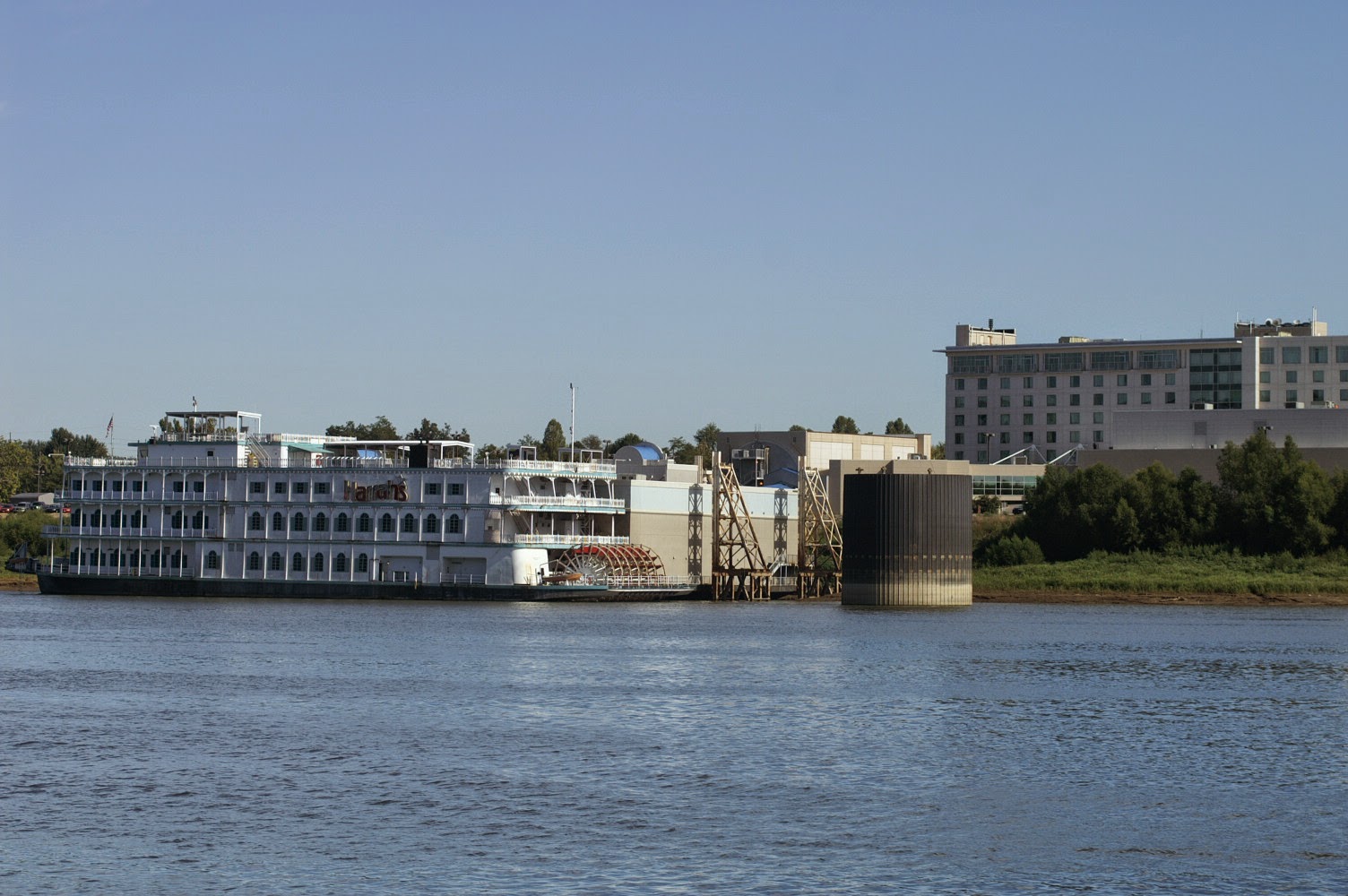
      We were slowed down to about 6.2 mph due to the current, which we had anticipated. This part of the Ohio River between Kentucky and Illinois is sparsely populated, except for Paducah, Kentucky near Lock #53 where we did pass under three very high fixed bridges. We passed this floating casino on the Illinois side. The hotel is up the back on the flood plain while the casino area was all floating with 2 large barges and the paddle wheel boat. I checked, and they did not have a drive through window for gambling so we did not stop...
        One of the nicest surprises was to pass the stern wheel cruise ship, the Queen of the Mississippi.


     It was quite a nostalgic view of the steamboat! However, since she was headed down stream (in the opposite direction), it was over all too quickly.
     We did have an option of routes on today's trip. We could have turned off the Ohio River into the Tennessee River after 30.2 miles, or we could continue up river to turn off into the Cumberland River after about 42.1 miles. If we had chosen to go through the Kentucky Lock and Dam. This route would have been shorter, but if also has the most commercial traffic. Since the commercial traffic has priority over pleasure craft, we got what is evidently the Lock Master's standard answer of a minimum of a 2.5 hour wait. We opted to continue up river to the Cumberland River where there is much less commercial traffic.
     The Cumberland River had very little traffic, and was pretty interesting. There were several large quarries where they shipped out barges loaded with gravel and sand. We have passed many quarries on the river system where they load sand and gravel onto the barges with conveyor belts. One quarry also shipped out large (1 to 2 foot size) rocks of the size that are used to "armor" the river banks against erosion. To load these large blocks of rock they used the large earth mover like trucks that would back out onto one of the three yellow ramps and simply dump the rocks directly into the barges. The ends of the ramps fold up when they are finished, like the one on the far right, so that the tow boats can push the barges out. You can barely see some very large piles of gravel in the background. Judging from the dust clouds, this must be very dirty work...
     Once we entered the Cumberland River, it was about 31 miles to the Barkley Lock and Dam. The current in the river was slightly less so we did pick up about a half mile per hour. Sunset was approaching by the time we reached the dam at about 7:15 pm. The picture at the right shows our group of four boats entering the Barkley Lock as the sun was setting. Fortunately, the gates were open as a tow had just exited headed down stream. By the time we exited the lock the sun had fully set so we proceeded slowly for the last two miles to the marina. It was one of those dark (no moon) nights, but fortunately, we could see the larger buoys on radar, and even the smaller ones had reflective patches on them. We had plenty of help with lines from other Loopers, and we were finished docking by 8:15 pm. It was a very long day in beautiful weather with very pleasant company on the other three boats. I guess that we had dinner, but I really don't remember anything else until the next morning...

Wednesday, October 1, 2014

Day 2-315 down The Mississippi River to the Ohio River and...

     We pulled up the anchor and left the anchorage at 6:55 am this morning. As a safety measure while anchored, we had two anchor alarms set to sound off if the boat moved more than 50 feet. The good news is that the anchor held very firmly so we slept uninterrupted. The current going down the Mississippi remained strong, and we must have averaged just over 12 mph while going down river today. Our trip was a total of 120.7 miles with the last 16.4 miles being up the Ohio River (and into the current). The picture at the right shows the sunrise with the sun peaking through the trees as we had just exited the anchorage and started to head down river.
     Yesterday I said that we had anchored for the night behind a wing dam. Calling it a "dam" kind of glorifies a wing dam. You can see (picture above) the pile of rocks that comes from shore out into the river, and it continues out under the surface of the water. It is not much of a dam, but it is enough to deflect the current away from the shore. The water in this picture is flowing from right to left, and behind the turbulence created by the wing dam, you can see that the surface of the water near the shore is smooth (i.e. very low current). Deflecting the current away from the shore is a way that the Corps of Engineers can control shoreline erosion. They are poorly marked on charts (or not at all on old charts). However, the patterns of the line of turbulence coming out from the shore is easy to recognize once you know what to look for... At least, I say it is easy to recognize them since I have not hit one (YET!).
     The downstream current continued to increase during the day. We gained at least 3 mph in the Mississippi River, and at times like just before we reached the Ohio River, the boost from the current was as high as 5 mph for a short time. The picture at the left shows the wave in front of the marker and some of the turbulence created down stream.

     The current as well as possible debris caught on either the marker itself or on the anchor chain resulted is several buoys that were literally under water most of the time. The picture at the right shows a marker buoys that is just under the surface. Part of the buoy did surface several times so we were sure that there was a buoy there and to avoid that spot...
     We did not pass many waterfront cities, but Cap Girardeau, Missouri was probably the biggest. The old down town areas probably once had nice waterfront views, but now the cities are behind tall dikes to protect them from flooding. Nice friendly greeting and murals, but we did not see much of the downtown. You can see one of several gates through the dike with one of two gates or doors in the closed position.

     Yesterday, I had mentioned that the number of barges in a tow had increased, and show the size difference between a medium sized towboat and a large two stacker. I could not get a picture of a 3 stacker with any of the smaller towboats. However, the photo at the right shows a 3 stacker pushing a tow up the Mississippi River. It has an extra deck for a total of five as well as a third engine. The lead barges create a "typical" V-shaped wake like a boat does. The towboats create a lot of turbulence (basically water swirling around) as well as these huge 7 foot high waves behind the towboat. Normally, it is a good idea to pass well behind any tow because of the turbulence, but these tall waves created by these 3 stackers add a whole new dimension to the danger.
     After a mere 104.3 miles, we turned to port (left) to head almost due north into the Ohio River (picture at left). Once again, the junction of these two mighty rivers was rather unremarkable. The city of Cairo, Illinois is just to the north of this junction up out of the flood plain to protect the city. We had been in the Mississippi River for a long distance, and it was very muddy due to recent flooding on both the Missouri and Illinois Rivers. It is not terribly obvious in this picture, but the Ohio River on this day was a much clearer, greenish color.
     This picture (at right) shows the sharp contrast between the clearer water in the Ohio River (top) and the muddy water (bottom) of the Mississippi River. The boundary is quite sharp initially, but a short distance downstream it is all mixed into the same muddy brown color. Please do not get the idea that one river is "cleaner" than the other. In flood stage the Ohio would be just as brown, and at other times the Mississippi could be clearer... Also, the Ohio River also doubles the amount of water in the Mississippi River, and it is truly a "mighty" river south of here. However, it is still not done "growing" as many other rivers, such as the Arkansas River, flow into it before it reaches the Gulf of Mexico.
      As at other junctions of major rivers, there is a huge staging area for barges. The tows south of here on the Mississippi River can have as many as 72 barges in them. Going up the Ohio or further up the Mississippi River, the tows are limited to the sizes of the locks and are much smaller at about 3 barges wide by 5 long. Over a couple of miles we wound our way through literally hundreds of barges anchored out in the river in groups. There were also many smaller tow boats putting tows together or taking them apart. It reminded me of a large railroad switching yard (without the tracks).
     Since we were now heading up the Ohio River and into the current, we slowed down to about 2 miles below our normal cruising speed. So, the last 16 miles of the trip for today was much slower as we went from 12+ mph in the Mississippi to about 6+ mph up the Ohio. Our destination today was an anchorage just down river from the new Olmstead Lock(s) and Dam, which is still under construction. Our guides said to call the Lockmaster for permission to anchor near a construction barge mooring area, and he was most accommodating. We anchored on the north side of the river just out of this picture to the left. There were already three other Loopers anchored there, and one other boat joined the group later. We anchored in about 8 feet of water just off the river bank, and after the long day, it was another evening where we were in bed shortly after 9:00 pm.