Sunday, June 25, 2017

Day 25 to an anchorage on Lake Champlain


       Our departure from the marina at about 10:00 AM was in a light wind so getting underway was a lot more relaxed than our arrival yesterday. We had a lovely view of Port Henry (photo at right) as we headed north toward an anchorage about 19.6 miles away. The marina was just out of view to the left, and the center of town is that cluster of buildings in the middle. That is the hill that we walked up for dinner yesterday only to find that the Chinese restaurant was closed.
      The photo at the left shows some of the shoreline on the west side of Lake Champlain. It was always heavily treed and occasionally with rocky wave cut cliffs. Lake Champlain is elongate in a north-south direction with the prevailing south and N-NW winds. These winds run parallel to the lake and make the lake seem like a wind tunnel.
      We saw few signs of civilization, but there were isolated cabins, including this lovely big house (photo at right). As you can see in the picture there is very little wind on the water here as we did go into several sheltered bays to see more of the scenery during our rather short trip today.
      Lake Champlain was formed by the continental ice sheet that moved south out of Hudson’s Bay. The lake is often two to three hundred feet deep, but there are a number of islands some of which are quite small (photo at left). The islands in the photo are small and difficult to see, but they are well marked on charts and with navigation aids. These two islands are surrounded by deep water so they must have been a different rock type that was more resistant to erosion by the glaciers.
      As we approached our anchorage, we passed this potential anchorage at an island (photo at right) that provides a lot of protection from northerly winds, but it is totally exposed to south winds. We opted for a small bay that provided protection from both southerly and northerly winds. We knew that the bay was shallow, and one local rule that we have learned is that water depths of less than 20 feet will have weeds on the bottom.
      We have met a number of people that were suffering from pollen allergies. In our chosen anchorage we could see this heavy coating of pollen on the water (photo at left). Evidence that Spring has not been here all that long… One disadvantage of our travel plans this year is that we have experienced heavy pollen in Texas, Ohio, central New York and now here on Lake Champlain – oh joy… 
     We arrived at our anchorage around 1 pm and attempted to anchor in about 10 feet of water that was close to a boat Launch ramp. The advantage of this particular spot is that the ramp would be an ideal place to land a kayak when we take Lucky to shore to do her business. We ate lunch while keeping an eye on how much we were dragging.  After lunch, it was clear that the anchor was not holding so we hoisted the anchor, cleaned off a big clump of weeds and tried again nearby.  Again, we could not get the anchor to set so we decided that we might have to move on.  However, we liked the area since the views were very nice (photo at right). So, we moved into a little deeper water away from the weeds and tried again.  Turns out there is some truth to the adage, the third time is the charm.  
      Once it was clear that the anchor had set very well, we lowered the kayak from the flybridge into the water.  Lucky and the Admiral then took a trip to shore and back to the boat (photo at left).  She will get another round this evening and then again in the morning.  The low tonight is 54 degrees and the high tomorrow is 70!  Yes!!!!


Saturday, June 24, 2017

Day 24 to Port Henry, NY


      We had a nice slow morning and left the marina around 10:20 am after our obligatory pump out. Lake Champlain is a no discharge zone, like everywhere we boat. You have to go 3 miles out into the open Gulf or Ocean before you are allowed to pump out overboard. What makes Lake Champlain different is that they require your overboard system to be dismantled. So, I took out a vacuum break at the top of a loop in the discharge hose of the system and capped off the ends before we reach Lake Champlain.  The fine is $500 if you haven't complied with their regulations.
       We made it to Port Henry and successfully docked at Van Slooten Harbor Marina. The photo at the right shows our view of the southern part of the city with the marina barely visible at the far left. The finger pier is short and narrow which added a little excitement to the docking process.  The Admiral had to sit on the dock at the end to keep from going for a swim while wrestling with the bow line. She reported that the water on her feet felt wet (ha, ha) and refreshingly cool!  It was down right hot for the third day in a row.  The one advantage today was a breeze.  Everyone is complaining because the temperature has hit 90 degrees each day.  Even for Texans like us, it was pretty zapping the previous two days as the light wind was at our back and therefore nonexistent while on the boat. Today was much better!  We plan on staying here just one night.  I promised dinner out, but unfortunately for me the only restaurant open on Monday night is Chinese. I love good Chinese food, but ordinary restaurant Chinese food, especially buffets, is not high on my list. 
        We had a walk of 0.8 miles to the restaurant that is right in the very center of town. The bad part was that we had to go up hill about 200 feet in what remained of the heat of the day.  Our walk took us through the historic old town of Ft. Henry, and as we crossed a railroad track, we were greeted with this Amtrak sign (photo at left). The restored, historic railroad station is now used as an Amtrak Station. The station is on the Montreal - New York City route and has one train each way per day.


      A little further up the hill we got a good view back at the old station as well (photo at right). The diesel engine on display is relatively new, but behind the engine is a vintage ore car and a caboose. Unfortunately, the caboose is largely hidden by the band stand, but it was modified from an ore car like the one in front of it.


      Then I turned around and took the photo on the left. It is the present town hall, but it was originally built as the company headquarters for the local iron ore mining company. This iron ore was historically important in steel making in the US well into the 20th century, and it was shipped via railroad to Ft. Henry where it was loaded on ships and barges for transport to steel mills on Lake Champlain. The marina is built on the site of the dock where it was loaded.


     The last photo (at right) was taken over the stern of Lucky Us at the marina. The railroad cars are being stored on an old siding that is probably where the ore was delivered. The concrete bulkhead was part of the dock where the ore was loaded for transport. None of the original buildings remained, but there was an extensive array of concrete foundations remaining.

     And now, back to the story about dinner out… We arrived at the main intersection downtown only to find that even the Chinese restaurant was closed. The Admiral searched again on Yelp and found a drive-in restaurant on the edge of town that was open. She even called to verify it. The good news was that the drive-in was across from the main entrance to the marina, and they made a pretty good fish ‘n chips. The really good news out of all of this is that they also had soft serve ice cream, which put me in a much better frame of mind….

Day 23 to Whitehall, NY


      Today we departed Ft. Edward, NY in high scattered clouds with the promise of a warm day. We will go through the 4 locks on the Champlain Canal with only one remaining at the start of the day tomorrow, and we will also cross a drainage divide between the Hudson River that flows south into the Atlantic Ocean and the artificial cut for the Champlain Canal that goes down into the drainage basin for Lake Champlain. The photo at the right is looking back at the Town Dock at Ft. Edward. The dock and the electricity were free, but technically there was only one 30 amp circuit for each boat. Luckily, we were able to use two circuits, which means that we were able to run both AC units.
      Perhaps our big excitement for today’s trip was passing a bald eagle in a tree that was no more than 50 feet away (photo at left). This was the closest that either of us had ever been to a bald eagle in the wild. Pretty neat!
       Less exciting was this derelict boathouse that we passed (photo at right). There was not much scenery today as the topography was low, and there were almost no houses, except for farm houses in the distance. This was especially true between Locks 8 and 9 as we were in a ditch as we crossed the drainage divide. There were lots of dairy cattle as well as planted fields.
       The photo at the left was taken looking back as we departed Lock 11, which was the second of two locks going down today. In keeping with the theme of very low topography (i.e. pretty flat) for today, all of the locks were between 10 and 15 feet up or down. There was no Lock C-10, which was replaced during one of several periods of rebuilding the canal. The drop between Lock C-9 and C-11 was only 12 feet over a distance of 9.6 miles. That is very flat. For example, even if the Earth were perfectly flat, it would be impossible to see something only 12 feet high from 9.6 miles away.
 
      The photo at the right was taken as we approached the town of Whitehall, which was our destination for today. There is a large park on the left (west) side with several boats at the town dock just before the bridge. While walking Lucky during the evening, we explored the park as you will see below.
      The photo at the left was taken from the park and shows Lucky Us (third boat, dark blue stripe along the top of the hull) moored at the town dock. You can also see that after a day with little topography, we are now surrounded by (low) hills.
      The park had a museum, tiered concert area and several outdoor exhibits.  We walked around a corner of the museum and came upon this large, life-sized (?), wood carving of a sasquatch (photo at right). Lucky even felt compelled to bark at the carving, which is kind of scary looking.
      The photo at the left shows a large part of the hull of the steamer USS Ticonderoga that had been the flagship during the battle of Plattsburg in 1814. So far on our trip up the Hudson River, most of the history has been related to the Revolutionary War. This has surprised me since a lot of the fighting during the War of 1812 was in the Hudson and Champlain Valleys. The original Champlain Canal was completed in 1823, and it opened up the town of Whitehall to transportation to New York City (and beyond). As a result, manufacturing flourished in Whitehall. Many of the original plants are still standing and have been placed on the National Register.
      Whitehall is also famous as the birthplace of the US Navy. On October 11, 1776, the American fleet was defeated by the British in the Battle of Valcour Island off the west coast of Lake Champlain. This battle delayed the British who then had to wait out the Winter of 1776-7 before continuing their advance to the south. This delay gave the Americans time to gather and equip men for what turned out to be the Battle of Saratoga in September and October of 1777. The American fleet consisted of at least one captured ship and new ships constructed in Whitehall during the summer of 1776. The ships were built by carpenters, riggers and blacksmiths recruited from as far away as Massachusetts, Connecticut and Rhode Island who used local timber to build the ships. Once again, Benedict Arnold played a key role in anticipating the British advance south toward New York City, and he was the one who assembled the fleet to at least delay the British. The construction of the fleet and the ensuing battle are viewed as the birth of the US Navy.

Tuesday, June 20, 2017

Day 22 to Ft. Edward, NY


      Today is the day that we have been looking forward to as we resume our Great Loop adventure. The rent car was not due back until Noon, but I was off at 8:30 am hoping to get back to Enterprise not long after they opened at 9:00 am. After a short wait, I was safely back at Schuylerville Yacht Basin about 10:30, and I was very pleasantly surprised to find that the Admiral had pulled Lucky Us about150 feet down the dock to get a pump out. After doing the daily engine room check, we were off at about 11:15am, but the trip was short lived as I soon discovered that the hydraulic steering was not working. So, we went back to the dock to fill the reservoir with fluid and look for leaks. I am sure that I have mentioned this before, but at idle speed the flow of water past the rudders is so slow that they really do not work. Slow speed maneuvering is done almost exclusively by putting one engine in forward and one in reverse to turn. Slower turns can be done with just one engine in gear. That is just the basics as you can do more than just turn, but I do not want to bore you with a full scale lecture… We put about a pint of hydraulic fluid in the reservoir for the upper helm, which is the highest point in the system. There are three hoses, two helm stations, one hydraulic pump and a single large piston that turns the rudder together. There is also a junction on the hydraulic pump with 9 inlets/outlets, three adjustment screws and four mounting screws. Other than all of that, it is a simple system. I found what appeared to be a slow leak at the junction box so I cleaned up some fluid and carefully placed several paper towels to narrow down the location of the leak.
      After that excitement, we left the dock again at 11:40 am. Given the uncertainty about our departure time, we had only planned a short day anyway so the extra delay was not a problem.  We headed toward Ft. Edward only 13.1 miles upstream. Our first lock was C-5, which was only slightly north of our walks along the old Champlain Canal from the Schuyler Yacht Basin. The photo at right was taken 0.7 miles past Lock C-5 with an excellent view of the dam with a high rate of flow. The lift at Lock C-5 was 19 feet and that put us at a level of 102 feet since we left Waterford at the start of the Champlain Canal. There were only scattered high clouds, and we were already well on our way to today’s high of about 90. Unfortunately, the light breeze was from behind us so it was really getting uncomfortable on the flybridge with essentially no breeze.

       There were several long, narrow islands on today’s route. We came through the channel on the left (photo at left) between the island and the mainland. This is the reason why the Lock C-5 and its dam were 0.7 miles apart. The lock was at the downstream end of an island in the middle, and the dam was at the upstream end of the same island. There was no apparent reason for this offset of the lock and dam, but perhaps they were built at different times (?).
      We had visited Lock C-6 by car the day before (photo at right) as you can see with the Admiral and Lucky standing on the lock wall in the photo. The weather was clear and sunny, which only heightened our desire to get back on the water. We have talked about this, and perhaps one of the reasons that we will know when our (big) boating days are over is that someday we might not get this same feeling…
     Also at Lock C-6 we were treated to an excellent view of an old lock from the original Champlain Canal (photo at right). The scale of the last two photos is different, but hopefully you can get a feel for how much smaller the old lock is than the new one. The lock is only about 10 feet wider than Lucky Us...
      The photo at the right shows another of the ubiquitous canal work boats with the distinctive blue and yellow paint scheme. They are an indication of the amount of work that it takes year around to maintain the canal system. We passed very little boat traffic, especially considering that today was a Saturday. We did pass perhaps 6 small boats fishing in the canal.
      We arrived at Ft. Edward in time to walk into town for a late lunch at a wonderful local restaurant. We both had excellent small steaks with a salad and a (dry) baked potato. We walked about a half mile to get to the restaurant, and from what we saw, the town was not in very good shape. We did pass two nicely restored period homes, and one of these is the 1777 McCrea house (photo at the left). The timing of the construction of this house is interesting since it was probably built during the time of the Battle of Saratoga in September and October of 1777. If you look at the front of the house you can see that the windows on the second floor are less than 2 feet below the windows on the third floor. I have seen this before where the windows on the third floor basically start at the floor. This avoids the necessity for dormers in the roof that would be necessary to raise the windows up to their normal height on the wall.

Day 9 to 21 in Schuylerville, NY (origina name was Saratoga)


      Ann was staying on the boat for the first 3 full days, and then I drove her to Fairhaven, NY to pick up her vehicle to drive back to Ohio. That drive was over 150 road miles each way, but it also served to remind us how far we had actually travelled on Lucky Us. The weather was scattered rain for most of Ann’s final few days, but she made the most of her time by walking all over Schuylerville soaking up the history. Speaking of history, the photos in this post are in no particular order, except all of the photos of historical places are at the end. On the Erie Canal we had passed one of the two “beer barges”, which was a big local event.
      Since, the 1970s, there has been almost no commercial traffic on the Erie Canal so the barges carrying the large tanks to the Genesee Brewery in Rochester were unusual. The Champlain Canal has some commercial traffic even today, and I was greeted with the view of this tug and a large, empty barge (photo above at right). Several local people standing near where I was hardly seemed to notice the passing of the tow. Later, I passed several barges waiting to be loaded at a gravel quarry. Quite a different feeling after seeing helicopter views on TV and hearing reports on TV and radio daily for at least 10 days.
      The photo at the left shows Lucky with a bored look that tells her opinion of the weather. Usually when I offer her a chance to go for a walk, she jumps up and heads for the salon door, but when she sees rain, she can put on the breaks very fast. I try to walk 3 to 5 miles with her every day, but when it is raining, that total goes way down with her approval.
      Downtown Schuylerville is active with a grocery, 7 restaurants, several churches but no real stores. Most of the remaining store fronts are for services like lawyers, music, laundromat, and teaching yoga, art and drums, etc. The only store is a thrift store that occupies two store fronts. The buildings are old and in reasonable condition (photo at right). So, it is a pretty little downtown, but it is a little different.
      One cute thing on main street was this horse painted to look like a cow (photo at left). Several
of the towns in previous stops also had (only) one painted animal in a prominent location (e.g. the painted mule in Waterford).
      Or is it a horse?  The next photo (at right) shows that the horse actually has two pairs of ears… That’s right there are both horse and cow ears on a horse tat is painted with spots like a cow... Somebody has a strange sense of humor.
        Judy at the marina has a green thumb, and she has planted a lot of flowers, including this brightly colored hanging basket (photo at left). There are a lot of long term summer residents in the mobile home park that is also part of the marina. Most of them are from this area, but they have retired to Florida and come back here every summer. Anyway, they all contribute to a very friendly atmosphere here.
      Schuylerville also has a long, well preserved segment of the original Champlain Canal (photo at right). There is a stream that flows into the old canal from the upper right, and the added water circulation keeps the canal in good shape. More and more small towns are restoring small segments of both the original Erie and Champlain Canals as a means of attracting tourists.
      The photo at the left shows another portion of the original canal with a gravel one lane road along the old towpath. Lucky and I walked about a half mile along here on one of our daily walks. It was fun walking along here and thinking back to the time when a team of mules was pulling a barge along this very spot…
      …and they’re headed down the straight approaching the finish line. Saratoga Springs, NY is a beautiful town about 8 miles west of Schuylerville. It and Lake George were a favorite summer home to many wealthy people from New York City since the very late 1800s. Horse racing has also been a large part of the local activities. We went to see some racing, but it was dirt track car racing at the Albany-Saratoga Speedway (photo at right). It is a 1/3 mile dirt track with about ten 8 lap qualifying races with 2 races for each class. The final races are usually 20 laps. Given the high speeds and short track, the races do not last very long, but they are very organized with never more than about 5 minutes between races.

      We had a great time at the races as can be seen in the smiling faces in the photo at the left. If you look closely, you can see that the Admiral is wearing a set of noise deadening head phones, which definitely helped her enjoy the races. I had not been to a short, dirt track race since I was in high school so I was definitely looking forward to this event. On the other hand, the Admiral had never been to one of these races, and as she said later, she was not at all sure that she would like it. Don’t hold your breath, but I do think that we will go again someday.
      In driving around the area we passed several osprey nest on top of electric power lines (photo at right). Someone went to some effort as the wire had been removed from the top of the pole and a wooden box had been added. The osprey population has really rebounded from near extinction in the 1960s due to the effects of the pesticide DDT that caused their eggs to have very thin shells that cracked very easily.
      This is the Gen. Philip Schuyler House on the west edge of Schuylerville. The town was ultimately renamed after Gen. Schuyler replacing the informal name of the area of Saratoga. This beautiful colonial style house is actually the third built on this site by members of the Schuyler family as the first two were destroyed by fire. As part of a recurring theme, this photo was also taken in the rain...


      There were several beautiful, old churches, including this one that looked abandoned and was for sale (photo at right). Some people buy old churches and convert them into a home, but this one was so large that it would cost a fortune to heat.  Anyway, it looked very sad sitting there…
      Just up the hill from the church in the previous photo at the right sits the Saratoga National Monument (photo at left). It was built to commemorate the 100th anniversary of the Revolutionary forces at the Battle of Saratoga that happened over several weeks in September and October of 1777. It sits at the edge of what looked like an old stream terrace, and it has a commanding view of the Hudson River over 150 feet below. Just to the west of the monument is Victory Woods where British General Burgoyne and his army retreated after losing the battle. They had previously laid down their arms in what is now a waterfront park in Schuylerville.
      The handsome gent in the photo is me for scale and shows some of the details in the monument (photo at right). The victory at Saratoga marked the first major victory for the Revolutionary Army since the Declaration of Independence was signed about 15 months before. By that point the British controlled New York City, the Hudson River Valley and north through Lake Champlain all the way to Montreal. The nearly 13,000 American troops outnumbered the 8,000 British (and Hessian) troops who were more heavily armed and well trained, professional soldiers. By the time the battle actually began, the British army was down to as few as 7,000 troops due to casualties and desertions while the Revolutionary forces were growing daily.
      The final battle began here about 8 miles south of Schuylerville (photo at left). The Revolutionary forces had set up fortified lines for defense to stop the British from advancing South along the Hudson River (river is near the top of the photo). Hessian forces were moving South along the river, and the line of cannons placed along the edge of this terrace some 70+ feet above the river. The Hessians were turned back in the face of cannon and musket fire raining down on them and rejoined General Burgoyne who decided to attack through the trees further up the hill.
       When the British moved up the hill to attack through the trees, they lost the advantage of their superior cannons that were useless in the trees. The British came out of the tree line and started to cross this field where they were met by intense fire from the defenders protected behind earthen works. This part of the battle was to prove the turning point, and Burgoyne’s army retreated to Saratoga where they ultimately laid down their arms. There were negotiations about the document that was signed. Burgoyne refused to use the word “surrender”, but that is what they did when they laid down their arms in what is now a Schuylerville park adjacent to the marina where Lucky Us was docked.
        I am standing next to one of the (few) cannons that the Revolutionary force possessed (photo at left). It could only fire a (very small) one pound ball, but at the range of a thousand yards it was accurate. I am also holding an umbrella because it poured during the entire tour of the battlefield.
      The photo at the right shows one of the high-tech cannons captured from the British. It could shoot a larger ball much further and with greater accuracy than any cannon in the US arsenal. There was no foundry in the US that could produce such a weapon. Thus, the 138 cannons captured from the British were a huge addition to the Revolutionary army. The cannons were used against the British for the rest of the war and proved particularly effective against the British in Boston.
       Patriot John Neilson’s farm house was used for planning and his fields were used for camping. During the early part of the campaign one of the smaller engagements was fought along the edge of his farm, but Neilson’s family had already moved to safety. This is an exact reproduction of the original farmhouse (photo at left).
      On May 30 we also visited the National Cemetery (photo at right) that is adjacent to the Saratoga Battleground National Park. Before it became a floating holiday, Memorial Day was fixed on May 30 so it seemed appropriate that we stop to visit and pay our respects. As far as national cemeteries go, it is a relatively new one, but of course, it is filling far too fast.
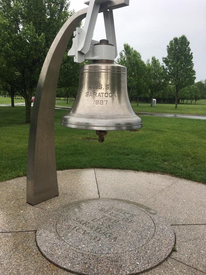
       The last photo (at left) from my extended stay in Schuylerville is the ship’s bell from the USS Saratoga, which is now on display at the Saratoga National Cemetery. I did not look it up, but I believe that the USS Saratoga was an aircraft carrier that played a prominent role in the battle of Midway Island in WW II. If I am not correct, I am sure that I will hear from my 7 year old Grandson Will who would know the answer.


Sunday, June 11, 2017

Day 8 into the Champlain Canal and north to Schuylerville, NY


       We set off from Waterford a bit later than planned at about 9:30 am. Ann and I headed off east into the Hudson River, and then we turned north to head up the Hudson River, which here is also known as the Champlain Canal, for a 21.9 mile trip to Schuylerville, NY.  After our “Lockathon” on Day 5 where we transited 11 locks, today we will go up only 4 locks for a total of 68.3 feet along the way. Our last lock on the Erie Canal was E-2, and Lock E-1 or the Federal Lock, as it is formally known, is further south (or down river) on the Hudson River near Troy, NY.  Thus, the Champlain Canal starts above Lock E-1, and we do not transit E-1 on this trip. Next year or whenever we stop spending summers on the Great Lakes, we would go through Lock E-1 on our way down the Hudson River to New York City and points south. The Hudson River is tidal until Lock E-1 so all we have to deal with are the wind and current. The photo above at the right shows our view toward the Hudson River as we left the dock in Waterford, NY. The thick clouds did burn off some, but we basically had a cool, cloudy day for the trip. My attire was the usual golf shirt with two, long sleeved but light weight sweaters, and on Day 1 I also had a light weight wind breaker as an additional layer. My theory is to dress in layers so that I can shed layers as it warms up. So far, that theory has only been put to use on one day…

       The photo at the left shows the lock and dam at C-3. The water was really cascading over the dam, and as we had seen along the canal, the lowest leaves on trees overhanging the water were often just below water level. The rains of the past two days had brought the water levels back up to nearer flood stage, but the daily emails from the Canal Corporation indicated that there were no closures on the Champlain Canal. Our visibility was somewhat limited otherwise I think that we should have been able to see the Green Mountains in Vermont to the east and the Adirondack Mountains in New York to the west.

      The photo on the right shows the interior of the lock chamber at Lock C-3. The red arrow shows a vertical pipe set in a recess in the lock wall. These pipes are mainly intended for commercial tows to tie onto so that their mooring line can slip up or down as the water in the lock goes up or down. Recreational vessels can use them by simply wrapping a line around the pipe. There are dire warnings to not tie the rope off on the boat. If the line becomes stuck on the pipe, the up or down movement of the lock will tear the cleat off the boat or even capsize small boats. Instead of the recessed pipes, some locks have heavy wire cables strung inside the recesses. Either way, the cables and the pipes are much cleaner than the ropes strung down the lock walls, and we prefer to use them when available.

      What we did see were old river terraces left behind as the Hudson River eroded down to its present level (photo at left). The terraces are very fertile and well drained so agriculture has always been big here. Today there are many dairy farms as well as sod farms. The milk and other dairy products have a ready market in New York City and vicinity. There were some bedrock hills that occasionally were right along the river. The bedrock is more resistant to erosion, and just as was the case in the Erie Canal, all of the modes of transportation get crammed into the narrow valley.
      Our destination for today is the small town of the Schuylerville, which as it turns out, was very important in the early part of the Revolutionary War. The town and surrounding area was originally called Saratoga, and the Battle of Saratoga was the first major victory for our fledgling country. So, I will be learning a lot of history while I wait for the Admiral. This beautiful yacht in the photo at the right was taking up nearly half of the fuel dock where we were supposed to stay. It was built by Burger Yachts in Wisconsin and is probably 30+ years old. There are many of these on the Great Lakes in particular. I had always wondered why a luxury yacht like this did not have a flybridge on it. Obviously, a flybridge would have made it too tall to traverse any of the canal systems, and it could have only left the Great Lakes by going out the St. Lawrence River and around the Maritime Province and New England. If you wanted to winter in Florida and summer on the great Lakes, making that long passage twice a year would have been an inconvenience, at best.

      Schuylerville is to be my “home” for the next two weeks until the Admiral returns from her trip back home to Texas. Ann, who has been such an able crew for the last week, will be returning to her home in Ohio in a couple of days. I will be getting a rent car to drive her back to her car, which was left at my brother’s home near Oswego, NY, which is over 150 (boat miles) from here. Thanks Ann for getting us started on this leg of the Great Loop Adventure.