We said goodbye to New York City this morning and headed up the Hudson River in thick haze and low clouds. We were headed against the outgoing tide and the flowing river so we were only going about 4.2 mph. It took us over an hour to get to the George Washington Bridge (picture above), and unlike the old days that is haze and not smog... As you might guess, the views on today's trip were not the best.
Our views of NYC were much different in the haze today as we left after three full days of very nice weather. We were close enough to One World Trade Center that the haze was not thick but the clouds were low.
We left the dock just after 8:15 am since we had 36.8 miles to go, and there were scattered thunderstorms predicted for mid (?) afternoon. When we docked at our destination, we had had a total of less than 15 minutes of light rain.
Today was the second day of Fleet Week in NYC. We saw one Navy ship coming into the harbor yesterday, and after the musical yesterday, the were lots of white dress uniforms out and about in the city. With Navy ships in port there was also a huge presence of Coast Guard and other law enforcement boats for security. The picture at the right shows one of the ships with just part of the four boat security detail for this one ship. We had our own "little" excitement when we (very lightly) brushed up against one of the patrol boats as we left the marina. They were taking a break at our marina, but luckily, the "Coasties" did not seem concerned since their bow is well protected. However, what concerned me was that we did come within a (very) few inches of touching the machine gun mounted on their bow...
Another (recent) classic view in the Harbor is the aircraft carrier Intrepid that now houses an extensive air museum. (Unfortunately) Houston did not get a "real" space shuttle, but there is a real one on display here... The picture on the left show the Intrepid with planes displayed on her deck. There is also a cruise ship in the background and two ferries rushing past in the foreground. Talk about a busy place...
Unlike today's first picture, we did get some okay views of the George Washington Bridge. The admiral also got a "lecture" on some of the local geology of this area.
The picture on the right shows the western (New Jersey) end of the bridge, which is anchored in the Palisades sill. I will spare you the lectures, but for you geology buffs, think -Triassic in age, rift related, rotated in the hanging wall of a listric normal fault AND near here is where N. L. Bowen did his field work.
He taught at Columbia University very near here, and he developed Bowen's Reaction Series for the Crystallization of Igneous Rocks. Note: end of lecture (for today). The picture at the left is of some actual outcrops of the basalt in the sill, which is several hundred feet thick. The steep rock outcrops form the western bank of the Hudson River for a distance of nearly 30 miles. The view is wonderful, and it has been preserved as park like for many miles along the west side. I think of this as very amazing/ironic in that the "city that never sleeps" is bounded by this beautiful park (and river) along most of its western side.
As mentioned earlier, we spent the entire trip today going against the tidal flow and normal river current. However, as we got further north, the river widened to nearly 3 miles wide and the tide was slowing and about to shift. Thus, we started the trip at 4.2mph, but as we went along we slowly gained speed to just over 8.4 mph. The final photo shows Half Moon Bay Marina, and the view is to the west toward the Hudson River. For dinner we walked about 0.7 miles to a wonderful (real) Italian restaurant in Croton-on-Hudson, NY. So, while we had spent time in New York (City), this is our first night officially staying in New York State. Another state added to the list...
Thursday, May 22, 2014
Wednesday, May 21, 2014
Days 2-189-191 in New York City Whoop!
Today is the end of our third full day at Liberty Landing Marina in New Jersey. I am (not very) sorry that I have not posted every day, but the Admiral has had us on a busy schedule.
The main event on Monday (Day 2-189) was dinner in Chinatown with Terry's 2nd cousin Bill and his daughter Katelyn. We took the ferry over to Manhattan (see picture at right). We walked over a mile to a Chinese restaurant chosen by Bill who used to work and live in Manhattan. It was fantastic! It turns out that he is a very good and informative tour guide as we walked past City Hall and on the way back we walked a little further north into the edge of Little Italy. We stopped for ice cream on the way back and then took a cab to the ferry landing since we were getting very close to the departure time for the last ferry of the day.
Tuesday (Day 2-190) we started off north from the marina to see a bit of the Jersey City side. The marina is on the south side of a half mile long channel that has other marinas and condos. We started off by taking the ferry across the 200 yard wide channel. It makes stops on both sides before going to Manhattan, and this little cross channel trip used to be free, but like everything else, it now costs $2.00. Kind of pricey for such a short ride, but I appreciated saving walking around the far end of the channel (twice). The picture at the left shows the boarding of the ferry at our marina, and our destination is essentially that high rise condo on the back right of the photo. Like I said, it was a short ride... For our mini tour we walked to a small, local Caribbean restaurant that seated about 14 people. The food was great as was the price, but it was spicy! After lunch I headed back to the boat for a nap while the Admiral walked a little further to a Radio Shack for some cables for the TV antenna.
After my nap and Terry installing two one foot long cables for a much better reception, we headed for the ferry to Manhattan. The picture at the right shows the ferry landing in Manhattan. It can accommodate 6 passenger ferries at a time and they really move them in and out as fast as they can. Our destination was the 9/11 memorial about 3 blocks away from the landing.
I had seen pictures of the memorial at Ground Zero, but of course, it was much better in person. It is a beautiful setting with a real feel of serenity in the midst of this busy city. We saw the museum, but it was only open to survivors and relatives of the victims. The Admiral met a lady in the marina who had come to NYC to be amongst the survivors who had early access to the Museum. Both she and her husband had been at work in different towers on 9-11. They were among the 35,000+ survivors on that day. The media gives a lot of attention to the number of victims on that fateful day, but obviously it could have been a lot worse.
On the way to the Memorial we passed very close to the base of the new One World Trade Center. This picture was taken about 100 feet out from the base of the tower, and the view is virtually straight up... It is only partially an optical illusion since the tower does get much smaller at the very top. There is still a lot of construction both above and below ground in this area, but we could already get a feel for the beauty of the final area.
On the way back to the ferry we stopped again at the movie theater complex near the ferry dock. We missed the first couple of minutes of "The Chef", but I found it to be a very enjoyable movie.
After the movie, we rushed to the ferry dock and managed to catch the next to last ferry for the day. This was our view back at the NYC skyline as we crossed the Hudson River on our ferry.
Wow! It was quite a day, and we still have one more full day to look forward to....
Day 2-191 is our last full day here, and the Admiral has been looking forward to this particular day for a long time. No, she is not looking forward to leaving! Today, we are going to see the Broadway musical "Wicked". From the ferry dock we walked about 6 blocks to the subway, which we took to the theater district. This was something of a thrill for me since in all of my previous trips to NYC I had never taken the subway. The plan was to arrive near the theater about 2 hours before curtain time and to have lunch at "The Three Monkeys". I had a Margarita Flatbread. Yup, by any other name it would be a flatbread pizza, but it was really delicious. I was even careful not to drink too much Diet Pepsi since I knew that the musical would last 2 hours and 45 minutes.
Of course, there were many famous sights in this area. We even went past the Ed Sullivan Theater with the Late Show sign.
I must admit to having been a little curious about the "Hello Deli" after so many weird stunts there on the Letterman Show. So, in case you ever wondered, it really is right around the corner from the Sullivan Theater...
After lunch, we went directly to the theater, which was just about to open its doors as we approached. The picture at the left was taken from our seats and shows part of the main curtain, which is a map of the Land of Oz, and the structure on the left is a series of gears and stairs that sits out in front of the stage.
Of course, there should also be the "obligatory" picture of the happy theater goers. So, here we are anxiously awaiting the start of the performance. Wow, I really enjoyed the musical and the whole experience in general!
In case you are wondering, I did have a tie in my pocket just in case, but I never even remotely felt the need to put it on...
Here is one more picture of our adventure to Broadway as part of a truly great day.
Was three and a half days in New York City enough? No way!
Will we be back? You can count on that!
The main event on Monday (Day 2-189) was dinner in Chinatown with Terry's 2nd cousin Bill and his daughter Katelyn. We took the ferry over to Manhattan (see picture at right). We walked over a mile to a Chinese restaurant chosen by Bill who used to work and live in Manhattan. It was fantastic! It turns out that he is a very good and informative tour guide as we walked past City Hall and on the way back we walked a little further north into the edge of Little Italy. We stopped for ice cream on the way back and then took a cab to the ferry landing since we were getting very close to the departure time for the last ferry of the day.
Tuesday (Day 2-190) we started off north from the marina to see a bit of the Jersey City side. The marina is on the south side of a half mile long channel that has other marinas and condos. We started off by taking the ferry across the 200 yard wide channel. It makes stops on both sides before going to Manhattan, and this little cross channel trip used to be free, but like everything else, it now costs $2.00. Kind of pricey for such a short ride, but I appreciated saving walking around the far end of the channel (twice). The picture at the left shows the boarding of the ferry at our marina, and our destination is essentially that high rise condo on the back right of the photo. Like I said, it was a short ride... For our mini tour we walked to a small, local Caribbean restaurant that seated about 14 people. The food was great as was the price, but it was spicy! After lunch I headed back to the boat for a nap while the Admiral walked a little further to a Radio Shack for some cables for the TV antenna.
After my nap and Terry installing two one foot long cables for a much better reception, we headed for the ferry to Manhattan. The picture at the right shows the ferry landing in Manhattan. It can accommodate 6 passenger ferries at a time and they really move them in and out as fast as they can. Our destination was the 9/11 memorial about 3 blocks away from the landing.
I had seen pictures of the memorial at Ground Zero, but of course, it was much better in person. It is a beautiful setting with a real feel of serenity in the midst of this busy city. We saw the museum, but it was only open to survivors and relatives of the victims. The Admiral met a lady in the marina who had come to NYC to be amongst the survivors who had early access to the Museum. Both she and her husband had been at work in different towers on 9-11. They were among the 35,000+ survivors on that day. The media gives a lot of attention to the number of victims on that fateful day, but obviously it could have been a lot worse.
On the way to the Memorial we passed very close to the base of the new One World Trade Center. This picture was taken about 100 feet out from the base of the tower, and the view is virtually straight up... It is only partially an optical illusion since the tower does get much smaller at the very top. There is still a lot of construction both above and below ground in this area, but we could already get a feel for the beauty of the final area.
On the way back to the ferry we stopped again at the movie theater complex near the ferry dock. We missed the first couple of minutes of "The Chef", but I found it to be a very enjoyable movie.
After the movie, we rushed to the ferry dock and managed to catch the next to last ferry for the day. This was our view back at the NYC skyline as we crossed the Hudson River on our ferry.
Wow! It was quite a day, and we still have one more full day to look forward to....
Day 2-191 is our last full day here, and the Admiral has been looking forward to this particular day for a long time. No, she is not looking forward to leaving! Today, we are going to see the Broadway musical "Wicked". From the ferry dock we walked about 6 blocks to the subway, which we took to the theater district. This was something of a thrill for me since in all of my previous trips to NYC I had never taken the subway. The plan was to arrive near the theater about 2 hours before curtain time and to have lunch at "The Three Monkeys". I had a Margarita Flatbread. Yup, by any other name it would be a flatbread pizza, but it was really delicious. I was even careful not to drink too much Diet Pepsi since I knew that the musical would last 2 hours and 45 minutes.
Of course, there were many famous sights in this area. We even went past the Ed Sullivan Theater with the Late Show sign.
I must admit to having been a little curious about the "Hello Deli" after so many weird stunts there on the Letterman Show. So, in case you ever wondered, it really is right around the corner from the Sullivan Theater...
After lunch, we went directly to the theater, which was just about to open its doors as we approached. The picture at the left was taken from our seats and shows part of the main curtain, which is a map of the Land of Oz, and the structure on the left is a series of gears and stairs that sits out in front of the stage.
Of course, there should also be the "obligatory" picture of the happy theater goers. So, here we are anxiously awaiting the start of the performance. Wow, I really enjoyed the musical and the whole experience in general!
In case you are wondering, I did have a tie in my pocket just in case, but I never even remotely felt the need to put it on...
Here is one more picture of our adventure to Broadway as part of a truly great day.
Was three and a half days in New York City enough? No way!
Will we be back? You can count on that!
Sunday, May 18, 2014
Day 2-188 Entering New York Harbor is an truly awesome experience!
Today was a really amazing day on the water. We left Brielle, NJ at 7:40 am and cleared the jetty about 10 minutes later. The weather prediction was very accurate. We had north winds of 5 to 8 mph, which resulted in "waves" of about 6 inches (well maybe a teensy bit more). There are always swells in the ocean, and once again, the predicted swells were about 3 feet with a long 8 second period (or wavelength). The swells just provided a gentle rocking/rolling motion to the boat. Our trip in the Atlantic Ocean was about 35 miles, but the general area of the harbor at NYC is huge so the great weather was most appreciated.
Once we cleared the highlands at Sandy Hook in New Jersey we were greeted by our first view of the new York City skyline and the view only got better over the next 15+ miles. As we got closer (photo at left) the Verrazono Narrows Bridge loomed large. The tanker is one of only three ships that we passed in the harbor. There were, of course, tugs, barges, many ferries, and several dozen sailboats racing. Still, it was nowhere near as busy in the harbor as I had expected/feared.

We took over 100 pictures today, but you can relax as I am going to spare you by not posting most of them. However, the Statue of Liberty is on the list that I will post. The first picture is not just one for the ego, but it also shows the aft end of the flybridge as visual proof that we were there (ha ha).
The second photo is one that really shows off Lady Liberty in all of her radiance! I have been there once before about 50 years ago with my mother on a vacation trip that included the 1964 World's Fair in NYC. I was impressed then, and it was if anything more impressive 50 years later.
Yes, those little "dots" around the base are people. If anything it is much larger than I ever would have expected.
Very close by on the New Jersey side of the harbor is Ellis Island. Actually our marina is only about a quarter of a mile to the right of the picture. There are quite a few other buildings in what is not surprisingly a large complex.
The skyline of NYC has always been impressive, and of course, now it is different with the recent completion of One World Trade Center. We plan to visit the memorial at ground zero tomorrow. The new museum officially opens on Wednesday, and although Wednesday is our last full day here, all of the tickets for opening day have long since been sold. At 1776 feet high to the top of the antenna, it certainly is an impressive addition to the skyline.
We are at Liberty Landing Marina on the New Jersey side of the Hudson. We took a ferry over to NYC to see the new movie "Million Dollar Arm", which by the way, I found quite good. The ferry left from our marina about a 5 minute walk away from Lucky Us. When we landed in NYC (see photo at right), it was only another 5 minute walk to the movie theater. It was a "cute" little ferry compared to the very large ones to places like Staten Island that transport thousands of commuters daily.
I will close with a picture of the skyline of NYC that was taken at dusk from the flybridge of Lucky Us at our dock.
Overall, today was one of the best days on our trip so far. Starting with great weather and including all of the many spectacular views, it was truly an awesome day!
Once we cleared the highlands at Sandy Hook in New Jersey we were greeted by our first view of the new York City skyline and the view only got better over the next 15+ miles. As we got closer (photo at left) the Verrazono Narrows Bridge loomed large. The tanker is one of only three ships that we passed in the harbor. There were, of course, tugs, barges, many ferries, and several dozen sailboats racing. Still, it was nowhere near as busy in the harbor as I had expected/feared.
We took over 100 pictures today, but you can relax as I am going to spare you by not posting most of them. However, the Statue of Liberty is on the list that I will post. The first picture is not just one for the ego, but it also shows the aft end of the flybridge as visual proof that we were there (ha ha).
The second photo is one that really shows off Lady Liberty in all of her radiance! I have been there once before about 50 years ago with my mother on a vacation trip that included the 1964 World's Fair in NYC. I was impressed then, and it was if anything more impressive 50 years later.
Yes, those little "dots" around the base are people. If anything it is much larger than I ever would have expected.
Very close by on the New Jersey side of the harbor is Ellis Island. Actually our marina is only about a quarter of a mile to the right of the picture. There are quite a few other buildings in what is not surprisingly a large complex.
The skyline of NYC has always been impressive, and of course, now it is different with the recent completion of One World Trade Center. We plan to visit the memorial at ground zero tomorrow. The new museum officially opens on Wednesday, and although Wednesday is our last full day here, all of the tickets for opening day have long since been sold. At 1776 feet high to the top of the antenna, it certainly is an impressive addition to the skyline.
We are at Liberty Landing Marina on the New Jersey side of the Hudson. We took a ferry over to NYC to see the new movie "Million Dollar Arm", which by the way, I found quite good. The ferry left from our marina about a 5 minute walk away from Lucky Us. When we landed in NYC (see photo at right), it was only another 5 minute walk to the movie theater. It was a "cute" little ferry compared to the very large ones to places like Staten Island that transport thousands of commuters daily.
I will close with a picture of the skyline of NYC that was taken at dusk from the flybridge of Lucky Us at our dock.
Overall, today was one of the best days on our trip so far. Starting with great weather and including all of the many spectacular views, it was truly an awesome day!
Saturday, May 17, 2014
Day 2-187 north to Brielle, NJ
We left Beach Haven at 7:50 am for a 44.3 mile trip to Hoffman's Marina in Brielle, NJ. The weather was beautiful but brisk (60F). This part of the Waterway is the last protected portion in New Jersey. From Brielle we will go out into the Atlantic Ocean for about 35 miles until we enter the harbor at New York City, which is very open (wide) until we get to our destination in Liberty Landing, NJ just opposite Manhattan Island. Thus, good weather is important, and the predictions are for north winds less than 10 mph and seas around 1 foot. That said, we know that there will be residual swells in the open Atlantic, but hopefully they will have a long wavelength so we just go gently up and down. That's the plan, but we will find out in the morning.
This most northern segment of the waterway was adversely effected by Hurricane Sandy so we were prepared for lots of shallow water. We did slow down several times when the depth sounder approached 0.0 feet. Otherwise, most of the trip was in uniformly shallow water with miles of about 2 feet below the keel. The "obligatory" marina photo at the right shows the small building with showers, washing machines, etc. It is almost hidden by the piling in the foreground. Like many marinas, Hoffman's seems to have sold off the parking lot/dry land storage area for condos. The area is very residential with a number of waterfront restaurants. We both had broiled shrimp, scallops, and flounder. Believe it or not, but we are about to leave the coast and really fresh seafood behind when we head up the Hudson River in a few days. Our choice of dinner was excellent!
The approach to the marina is through a railroad bridge where the open channel is only 30 feet wide (remember we are 15 feet beam/width). The river channel is also narrow and generates tidal currents of about 3.9 mph. The combination of narrow channel and fast currents generates a LOT of caution messages. Our dock is at the end of a T-head (at the end of a pier. Normally this is our favorite place, but we are about 50 feet from the railroad bridge. The picture at the left shows an Amtrak commuter train crossing the bridge, and it was taken from the flybridge of Lucky Us. Like I said, we are close to the bridge. The "irregular" surface of the water is the turbulence as there was no wind when the picture was taken. The fast current generates standing waves up to 1 foot high and lots of turbulence (swirling water). Thus, the Admiral will get her dream wish of getting "rocked to sleep". Hopefully, the rocking will be gentle (for the benefit of the Captain).
As I have said before, our grandson Will is crazy about trains (and tugs). The picture at the right shows the length (or in this case closeness) that a grandfather will go to get a picture for a grandson...
You can see the bow of Lucky Us to my immediate left out at the end of the pier. Close to the bridge???
The last picture shows the mouth of the Masaquan River as viewed from our dock. There is a large Coast Guard Station on the right, and the breakwater and channel out to the Atlantic are in the low area in the center.
This most northern segment of the waterway was adversely effected by Hurricane Sandy so we were prepared for lots of shallow water. We did slow down several times when the depth sounder approached 0.0 feet. Otherwise, most of the trip was in uniformly shallow water with miles of about 2 feet below the keel. The "obligatory" marina photo at the right shows the small building with showers, washing machines, etc. It is almost hidden by the piling in the foreground. Like many marinas, Hoffman's seems to have sold off the parking lot/dry land storage area for condos. The area is very residential with a number of waterfront restaurants. We both had broiled shrimp, scallops, and flounder. Believe it or not, but we are about to leave the coast and really fresh seafood behind when we head up the Hudson River in a few days. Our choice of dinner was excellent!
The approach to the marina is through a railroad bridge where the open channel is only 30 feet wide (remember we are 15 feet beam/width). The river channel is also narrow and generates tidal currents of about 3.9 mph. The combination of narrow channel and fast currents generates a LOT of caution messages. Our dock is at the end of a T-head (at the end of a pier. Normally this is our favorite place, but we are about 50 feet from the railroad bridge. The picture at the left shows an Amtrak commuter train crossing the bridge, and it was taken from the flybridge of Lucky Us. Like I said, we are close to the bridge. The "irregular" surface of the water is the turbulence as there was no wind when the picture was taken. The fast current generates standing waves up to 1 foot high and lots of turbulence (swirling water). Thus, the Admiral will get her dream wish of getting "rocked to sleep". Hopefully, the rocking will be gentle (for the benefit of the Captain).
As I have said before, our grandson Will is crazy about trains (and tugs). The picture at the right shows the length (or in this case closeness) that a grandfather will go to get a picture for a grandson...
You can see the bow of Lucky Us to my immediate left out at the end of the pier. Close to the bridge???
Friday, May 16, 2014
Day 2-186 Weather day (off) in Beach Haven, NJ
With strong winds (gusts up to 30 mph) and rain predicted for today, we had planned to stay at the dock today. It was not all that lazy since I had to get up early (8:30 am) to take the Admiral to breakfast at "The Chicken or the Egg" where we had dinner last evening. I complained but not too loudly, since I had already scoped out the breakfast menu. I had Texas Style French Toast covered with apple cobbler... Wow! Talk about a sugar high! When we got back to Lucky Us, I fought a valiant fight, but I ended up taking my afternoon nap in the late morning.
I did not have to feel very guilty since the Admiral had stopped on the way back to make an appointment for a little pampering -aka a pedicure. Also, when she left the boat, I was banished to the engine room to make the daily engine check. While I was down there having a "fun time", I also did a couple of other (very) small jobs. Actually, I wanted to be down in the engine room appearing to be still slaving away when she returned...
The wind gusts probably never got up to 30 mph, but we certainly had rain on and off all day long. So, it was a good day to have been in port. The weather forecast for tomorrow is much better with no rain and only 15 mph winds so we may well move on in the morning. We have been moving north up the east coast since last July when we reached Stuart, FL on Day 65!!! After 121 days, including days in port, we finally are very close to New York City. That fact was made even more obvious when we hooked up the cable TV provided by the marina. The local cable TV channels are from NYC. Yup, we are getting close...
I did not have to feel very guilty since the Admiral had stopped on the way back to make an appointment for a little pampering -aka a pedicure. Also, when she left the boat, I was banished to the engine room to make the daily engine check. While I was down there having a "fun time", I also did a couple of other (very) small jobs. Actually, I wanted to be down in the engine room appearing to be still slaving away when she returned...
The wind gusts probably never got up to 30 mph, but we certainly had rain on and off all day long. So, it was a good day to have been in port. The weather forecast for tomorrow is much better with no rain and only 15 mph winds so we may well move on in the morning. We have been moving north up the east coast since last July when we reached Stuart, FL on Day 65!!! After 121 days, including days in port, we finally are very close to New York City. That fact was made even more obvious when we hooked up the cable TV provided by the marina. The local cable TV channels are from NYC. Yup, we are getting close...
Thursday, May 15, 2014
Day 2-185 said Goodbye to the broken hot tub...
For the first night in a long time, I slept straight through the night. Well, the fun ended when I got up... As I said yesterday, the Admiral could not wait to get out of Atlantic City. I had barely finished the engine room check when she said "Can I start the engines yet?" We left the Golden Nugget Marina in light fog and 10 to 15 mph winds out of the southeast. Well, one of these days we are going to stay in a marina with a (heated) pool and/or hot tub that is actually open, but I am not holding my breath.
Our journey north took us 20.6 miles up the Intra Coastal Waterway to Beach Haven, NJ. The route took us through more beautiful coastal marsh and well away from the heavily populated barrier islands. We heard a call on the VHF radio requesting a tow from Tow Boat US from a boat that was grounded about 20 markers north of us. The channel markers are numbered sequentially with red being even numbers and green being odd. It was not a distress call, but rather he was firmly stuck in the soft muddy bottom. The picture on the right shows the scene as we passed. He was pretty clearly about 200 feet outside the channel, and the towboat is going to have to hurry since the tide is falling. It is now 8:00 pm, and these two boats just came into an adjacent marina so it took 8 or 9 hours to get him pulled into deeper water. We are already close to the area of New Jersey that was heavily impacted by Hurricane Sandy in 2012 so some of the channels are still silted in quite a bit. The ICW channel should be 12 feet deep at mean low tide, but in places we have had 6 feet or less for several miles at a stretch.

Speaking of (naturally) shallow water, we passed several uniformly flat, shallow areas full of fish stakes. Some of these are painted white while others were real natural branches from trees. I suppose that these are part of various signs indicating ownership. The stakes are pushed into the muddy bottom and have a short line with a baited hook.
We are staying at the Beach Haven Yacht Club Marina, and we are their first transient visitor of the season. Evidently the fuel dock is open all year, but the marina closes for 6 months or so. In the late afternoon we walked the 6 blocks to the Atlantic Ocean. The beach area was chilly since the water temperature in the Atlantic Ocean is 56F. Aside from one surf caster, we had the entire beach to ourselves. The town is also relatively deserted, and most of the businesses are closed with signs saying that they will open for the season on Memorial Day.
We did find a large, but quaint local restaurant open for dinner as we were headed back to Lucky Us. The "The chicken or the egg" has a long and varied menu. I had a grilled crab cake that must have been 100% crab meat. Wow! Luckily, the Admiral is already dropping hints about going back there for breakfast since we are staying here another night due to predicted rain and high winds tomorrow. Let's see... For breakfast I might just have to start with a short stack of pancakes smothered in peach cobbler. Oh, poor me...
Our journey north took us 20.6 miles up the Intra Coastal Waterway to Beach Haven, NJ. The route took us through more beautiful coastal marsh and well away from the heavily populated barrier islands. We heard a call on the VHF radio requesting a tow from Tow Boat US from a boat that was grounded about 20 markers north of us. The channel markers are numbered sequentially with red being even numbers and green being odd. It was not a distress call, but rather he was firmly stuck in the soft muddy bottom. The picture on the right shows the scene as we passed. He was pretty clearly about 200 feet outside the channel, and the towboat is going to have to hurry since the tide is falling. It is now 8:00 pm, and these two boats just came into an adjacent marina so it took 8 or 9 hours to get him pulled into deeper water. We are already close to the area of New Jersey that was heavily impacted by Hurricane Sandy in 2012 so some of the channels are still silted in quite a bit. The ICW channel should be 12 feet deep at mean low tide, but in places we have had 6 feet or less for several miles at a stretch.
Speaking of (naturally) shallow water, we passed several uniformly flat, shallow areas full of fish stakes. Some of these are painted white while others were real natural branches from trees. I suppose that these are part of various signs indicating ownership. The stakes are pushed into the muddy bottom and have a short line with a baited hook.
We are staying at the Beach Haven Yacht Club Marina, and we are their first transient visitor of the season. Evidently the fuel dock is open all year, but the marina closes for 6 months or so. In the late afternoon we walked the 6 blocks to the Atlantic Ocean. The beach area was chilly since the water temperature in the Atlantic Ocean is 56F. Aside from one surf caster, we had the entire beach to ourselves. The town is also relatively deserted, and most of the businesses are closed with signs saying that they will open for the season on Memorial Day.
We did find a large, but quaint local restaurant open for dinner as we were headed back to Lucky Us. The "The chicken or the egg" has a long and varied menu. I had a grilled crab cake that must have been 100% crab meat. Wow! Luckily, the Admiral is already dropping hints about going back there for breakfast since we are staying here another night due to predicted rain and high winds tomorrow. Let's see... For breakfast I might just have to start with a short stack of pancakes smothered in peach cobbler. Oh, poor me...
Wednesday, May 14, 2014
Day 2-184 First Anniversary of the start of our trip -Whoop!
OK sports fans. We left League City, TX on May 14, 2014. Here we are one year later and still having a BLAST! In that year we have "counted" 184 days in this blog as travel days, but in addition, we spent 3+ weeks in Wilmington, NC getting Lucky Us ready to spend the winter there, and we spent about 4 weeks in late February and March getting ready to re-start our trip. So, we spent about 235 days on the boat during that year, and we have travelled 3,539 miles during that time. All of this "history" is really neat, but we still are only about halfway done. So, let the fun continue!
Back to reality... We left Cape May, NJ this morning headed to Atlantic City 54.3 miles north in light fog with visibility of over 1 mile. The weather prediction had been for wind to subside to 8 to 10 mph over night and shift from north to southeast with no mention of fog. The reality was that the wind did not shift and the velocity dropped a little to 10 to 15 mph. However, we were ready to "bust out" of Cape May after 8 days there so we left in safe but less than perfect weather. We went through beautiful coastal marsh for most of the journey. As usual, when the Intra Coastal Waterway goes through the marsh, the waterway is a combination of old, winding river channels that are connected but artificial cuts. Thus, even though it is only 35 miles as "the crow flies" from our berth in Cape May to Atlantic City, it took us 54.3 miles to get here. Another "oddity" of the trip is that we made 245 turns (or parts thereof) today as compared to something more like 50 on a typical days run. Obviously, the repairs to the hydraulic steering that we had done in Cape May seem to have had a really good test today and passed with flying colors. The picture at the right shows my uniform for the day that consisted of a toque, sweater, jacket and (life jacket) vest and gloves... Did I forget to mention that the temperature of the Atlantic Ocean is 56F in this area? Rather than run the generator and use our electric space heater, we opted to bundle up and keep the windows closed to cut out the breeze.
I did mention the fog, and in this photo of one of the casinos in the area you can see the light fog/haze down low and the low "clouds" higher up. If this grouping of hotel, casino, convention center and parking looks isolated to you, then you are correct. As everyone knows, the casinos are very adept at getting you to spend money. Gone are the free meals, free drinks, free or cheap rooms, etc. Many of the newer casinos in Atlantic City are isolated. The isolation might mean remote location or merely being surrounded with limited access roads, interchanges, etc. with no sidewalks. Even the shuttle that connects casinos, which used to be free, now costs $2.50 per trip. In the background at the right, you can see another casino, which illustrates the isolation and the fog.
In addition to the winding route today, we went under 11 bridges and had to have 5 more bridges open for us to pass. The state of new Jersey becomes more densely populated as you go north toward New York City, and the barrier islands have long been densely populated at least during the summers when the Atlantic Ocean serves as natural air conditioning. Thus, more bridges to serve the (many) barrier islands. Since the busy season goes from Memorial Day to Labor Day, the traffic is still somewhat low. As a result, all of the bridges opened more or less immediately with only a call on the VHF radio. In the summer season all of these bridges open on fixed schedules ranging from every 20 minutes to only once per hour, which could easily have added several hours to our trip.
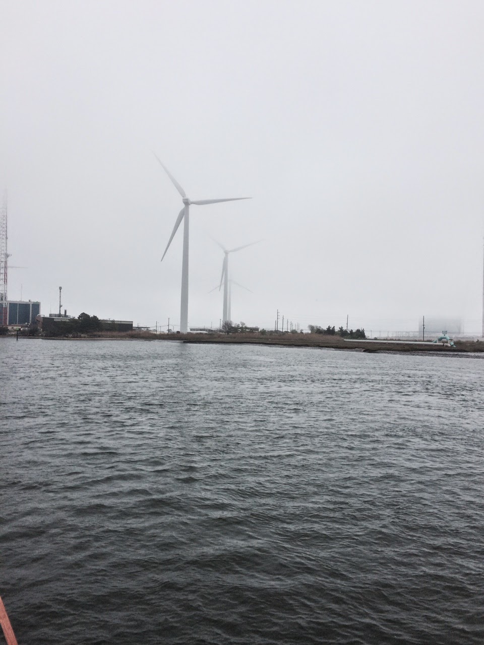
I included this last picture as sort of the "oddity of the day". When I think of cities like Las Vegas and Atlantic City, I have this mental picture that is sort of like Times Square. Lots of gaudy signs, flashing lights, etc. When thinking about this image, the last thing that comes to my mind is green energy, and yet here in Atlantic City between two of the casino areas there is this grouping of 5 (yes, five) wind generators. Do not think for even a second that this token effort will change my view of excessive energy use in casino towns...
Last but far from least:
Never and I repeat never disappoint the Admiral! One of the attractions of the Golden Nugget was not just a wonderful marina adjacent to the casino, etc. The real attraction was the HOT TUB and HEATED POOL! When we were checking into the marina, the Admiral asked directions to the hot tub, and she was informed that the pool and hot tub were closed due to a mechanical breakdown. The lady at the desk will never know how lucky she was at that moment. Fortunately, there was no nuclear meltdown, but instead of staying two or more nights, we are leaving in the morning. Just to add her personal revenge, the Admiral is leaving here a winner. She increased her money by 120% at the casino tonight. So, take that Golden Nugget!
Back to reality... We left Cape May, NJ this morning headed to Atlantic City 54.3 miles north in light fog with visibility of over 1 mile. The weather prediction had been for wind to subside to 8 to 10 mph over night and shift from north to southeast with no mention of fog. The reality was that the wind did not shift and the velocity dropped a little to 10 to 15 mph. However, we were ready to "bust out" of Cape May after 8 days there so we left in safe but less than perfect weather. We went through beautiful coastal marsh for most of the journey. As usual, when the Intra Coastal Waterway goes through the marsh, the waterway is a combination of old, winding river channels that are connected but artificial cuts. Thus, even though it is only 35 miles as "the crow flies" from our berth in Cape May to Atlantic City, it took us 54.3 miles to get here. Another "oddity" of the trip is that we made 245 turns (or parts thereof) today as compared to something more like 50 on a typical days run. Obviously, the repairs to the hydraulic steering that we had done in Cape May seem to have had a really good test today and passed with flying colors. The picture at the right shows my uniform for the day that consisted of a toque, sweater, jacket and (life jacket) vest and gloves... Did I forget to mention that the temperature of the Atlantic Ocean is 56F in this area? Rather than run the generator and use our electric space heater, we opted to bundle up and keep the windows closed to cut out the breeze.
I did mention the fog, and in this photo of one of the casinos in the area you can see the light fog/haze down low and the low "clouds" higher up. If this grouping of hotel, casino, convention center and parking looks isolated to you, then you are correct. As everyone knows, the casinos are very adept at getting you to spend money. Gone are the free meals, free drinks, free or cheap rooms, etc. Many of the newer casinos in Atlantic City are isolated. The isolation might mean remote location or merely being surrounded with limited access roads, interchanges, etc. with no sidewalks. Even the shuttle that connects casinos, which used to be free, now costs $2.50 per trip. In the background at the right, you can see another casino, which illustrates the isolation and the fog.
In addition to the winding route today, we went under 11 bridges and had to have 5 more bridges open for us to pass. The state of new Jersey becomes more densely populated as you go north toward New York City, and the barrier islands have long been densely populated at least during the summers when the Atlantic Ocean serves as natural air conditioning. Thus, more bridges to serve the (many) barrier islands. Since the busy season goes from Memorial Day to Labor Day, the traffic is still somewhat low. As a result, all of the bridges opened more or less immediately with only a call on the VHF radio. In the summer season all of these bridges open on fixed schedules ranging from every 20 minutes to only once per hour, which could easily have added several hours to our trip.
I included this last picture as sort of the "oddity of the day". When I think of cities like Las Vegas and Atlantic City, I have this mental picture that is sort of like Times Square. Lots of gaudy signs, flashing lights, etc. When thinking about this image, the last thing that comes to my mind is green energy, and yet here in Atlantic City between two of the casino areas there is this grouping of 5 (yes, five) wind generators. Do not think for even a second that this token effort will change my view of excessive energy use in casino towns...
Last but far from least:
Never and I repeat never disappoint the Admiral! One of the attractions of the Golden Nugget was not just a wonderful marina adjacent to the casino, etc. The real attraction was the HOT TUB and HEATED POOL! When we were checking into the marina, the Admiral asked directions to the hot tub, and she was informed that the pool and hot tub were closed due to a mechanical breakdown. The lady at the desk will never know how lucky she was at that moment. Fortunately, there was no nuclear meltdown, but instead of staying two or more nights, we are leaving in the morning. Just to add her personal revenge, the Admiral is leaving here a winner. She increased her money by 120% at the casino tonight. So, take that Golden Nugget!
Subscribe to:
Posts (Atom)