We left the wall at the Littlefield Lock promptly at 9:00 am to begin our journey today. We had a short wait at the gate, but it gave me a chance to get a picture of the Savage Arms Company plant on the town side of the water (photo at right). If we make it all of the way to Peterborough, we will have 7 locks today... The Admiral called yesterday, and we can have a dock today if we get that far. Our original reservation was for tomorrow, but with the rainy weather today we might as well slog along to Peterborough if the weather and locks cooperate.
When we checked the forecast again this morning, it still does not include adverse weather like lightning or high winds. The rain will be uncomfortable, but at least it is not cold. The photo at the left shows something of my restricted view from the helm out through the windows. I am steering, which I often do in the rain rather than use the autopilot. I need to pay close attention with the thick haze and steering keeps me focused.
We did not share a lock all day, and we only passed two boats total at all of the locks, and they were both going in the opposite direction. The photo at the right is the campus at Trent University, and it appears that we went right through the campus. There were three pedestrian bridges, which must be fun in snow and/or ice. It was too bad that the weather was bad since the Trent campus is supposed to be know for its architecture.
We had about four swing bridges today, and the one in the photo at the left was not included in the count since it has obviously been out of service for a long time. The railroad tracks have even been removed, and there were small trees actually growing up through the bridge...
The highlight of today's trip was the Peterborough Lift Lock, which is the second and last of the lift locks on the Trent-Severn Waterway. The lift is 65 feet, which makes the view from the top both awesome and scary. In the photo at the right we are approaching the lock with both gates in the up or closed position. The red lights are both lit, which indicates that we, of course, do not have permission to enter. The yellow arrow points to the left indicating that we will ultimately enter that lock. The left lock is in the up position, but it is difficult to see yet in this view.
In the photo at the left the gate is down for us to enter when we get the green light. After we enter, the gates will come back up behind us. Gates is plural because there are two gates. One will stay in place to act as a dam for the water above. The other gate forms part of the lock or "box" that is filled with water and will carry us down 65 feet. Now you can see that the other gate is still closed because the lock for it is down at the bottom.
The photo at the right shows us in the lock with Lucky Us securely tied to the side. The view out the front over the bow is awesome! It looks very much like we are flying. At this point we are inside the lock chamber with the gates behind and in front of us in the closed position. The entire lock will now move down, and it is balanced so that the other lock will move up at the same time.
The photo at the left shows the two locks passing each other at the halfway point. The lock on the left is going up while we are going down. At the top of the picture you can see the two lock gates that are fixed at the top of the lock. They are both holding back the water at the top, and they are hinged at the bottom so that they can rotate down (away from the viewer) when a lock is in the up position.
In the photo at the right our lock is now in the down position. Before we can exit the lock, the gate in front of Lucky Us must be lowered. The photo is looking back over our stern, and you can see the gate through which we entered at the top. The dark wall has what appears to be a window with bars on it. In fact it is a window, and on the other side of the window is a road carrying traffic from one side of the lock to the other. The stairs on the right side of the photo also lead up to the road from the lower level of the lock. Most of the locks have a bridge from one side to the other, but this lock is so high that they just built what amounts to a tunnel into this wall of the structure.
In the photo at the left the gate in front of us has been lowered, and we are in the process of exiting the lock. This view is also looking back over the stern of Lucky Us. You can see the other lock on the left is in the fully raised position. The locks are "balanced" not by a lever arm but by a huge piston under each lock, and you can (barely) see the black, round piston under the lock in the up position.
We are still several miles by water from our destination, but in straight line distance we are only a mile or less from both downtown Peterborough and the marina. The photo at the right shows a canoe on the lock wall advertising the canoe museum at the visitor's center, which is just up the hill. It is actually a modern fiberglass canoe painted to look like a historic birch bark canoe. They offer tours to as many as 18 people (who actually pay) to paddle the canoe for a short trip. What is unique about the trip is that they paddle into the lock and take a trip up and down in the lock. Must be quite a thrill as well as maybe a bit scary (?)!
The Ashburnham swing bridge is our last bridge for the day. It is unique in my experience in that the bridge is off center on the rotating mechanism. Usually the swivel is in the middle so that the bridge is balanced. In this case, they have added concrete weights to the short side to balance the bridge. Anyway, I did a double take at the off centered nature of the bridge, but it does work as was demonstrated for us in a couple of minutes.
The last lock for today was the Ashburnham Lock with a drop of only 12 feet. Once again, we were the only traffic, and they were waiting with the gate open for our arrival. Since the Peterborough Lift Lock, there has been a wide bike path and park on the right side and a highway scenic route on the other side. The tourist bureau advertises land travel routes to follow the canal and see the locks in action. The view on the other side of the lock is of Little Lake where our marina is located out of sight off to the right.
As if we were not already totally soaked from all of the rain, they have this huge fountain that shoots water 50+ feet into the air in the middle of the lake (photo at left). The wind carries the spray from the fountain virtually across the small lake and more importantly, into our path. Just what we needed...
The last photo shows our destination at Peterborough Marina. The Admiral was already making plans for a nice hot shower, which I might add she well deserves. She spent a lot of time out on the fore deck handling lines at locks, which was a nasty job today. The larger white building on the left is the marina office. Out behind the office is a large covered stage and a several acre area for spectators. Most Wednesday and Saturdays in July and August they have free concerts there with an audience of from 8 to 12,000 people. We already have plans to go see "Hotel California" there tomorrow night. They are an Eagles tribute band that is billed as "They don't imitate, they duplicate". Now, that is going to be good music!
Wednesday, August 24, 2016
Sunday, August 21, 2016
Day 136 to Lakefield, ON
We left Buckhorn after eating out for lunch (photo at right). We first went to the restaurant from lunch yesterday, but they were out of pickerel due to heavy demand over the weekend so we went to the third restaurant to try it. Of course, I tried the fish 'n chips, and it was quite good. What can I say, but I'm in a rut when it comes to fish 'n chips...
We had multiple possible destinations including one just 5 miles away. After reviewing the weather forecast which is for rain all day tomorrow, considering we have a reservation at a Marina in Peterborough on Wednesday, and considering that we have 11 locks between Buckhorn and Peterborough, we decided on going to Lakefield, Ontario. This will mean four locks and possibly a fifth lock depending on which side of the lock we stay at in Lakefield. None of the lock wall possibilities included hydro power so we will be opening windows and using the generator some.
By the time that we finished lunch about Noon, the traffic through the lock had slowed down, and the lock wall was down to mainly boats that were staying over another day (see photo at left). We had arranged to stay past the 11:00 am check out and had made sure that we had also unplugged the electric so that we did not get charged for another day. We got ready and just waited where we were rather than move over to the blue line on the other side of the channel. We made the next down locking with only one small boat for company.
The photo on the right shows a view of the dam taken while we were still up in the lock and offers a little different perspective. Aside from the three restaurants and a church there is no development near the lock and dam on either side so our views were always very nice. You also can see the walkway on the downstream side of the dam where I was standing when I took the picture of the spillway in yesterday's post.
The photo at the left was taken from the flybridge looking back at the lock after Lucky Us and the small boat had exited the lock chambers. A small houseboat has already entered the lock for the next lock up. There always seems to be a rush to enter the lock, and the lock masters do not seem to mind since it keeps the traffic moving quickly. Remember that there is no power on the lower walls of this lock so all of these boats are probably headed up even if they plan to stay here.
The scenery was excellent, and the piloting had some of the usual tense moments, such as this narrow part of the channel (photo at right). I still exercise caution in narrow places like this, but I am growing more accustomed to having these areas pop up regularly on our routes. At least they are well marked, and most of the small boats simply bypass these tight spots by going around one of the islands on either side so the traffic is often light in the narrow part shown here.
The photo at the left shows the unusual exit from the lock at Burleigh Falls, Ontario. Even though we came down in the lock, we did not come out into an open space, but we were in a dug out channel with vertical concrete walls and tall trees. It felt kind of tunnel like as we moved along through here.
The photo at the right shows a fairly large church, which might not sound too unusual, but this church is on an island with no bridge to it. I suppose that there would be no need for a parking lot. However, in our view of the island we did not see even a small dock for boats, which must have been there somewhere (?). Obviously, the church is "open" and well cared for so the members get there somehow.
We arrived at Lakefield where we were going to spend the night on the lock wall. The last half mile or so was in this narrow, straight, man made channel to the upper lock wall. The channel was cut into bedrock, which can be seen in the photo at the left. The vertical channel wall from water level up six feet or so is definitely bedrock. Then there is a grassy bench with what may be a rock retaining wall above it. The channel was so narrow that I was really happy that we did not pass any boats while we were in it. We are going to stay on the upper lock wall because the access to the town of Lakefield is better from there.
The photo at the right shows part of the Lakefield Dam and power plant. I took the picture standing on a sidewalk along a road over the actual dam. The power plant is in the center top. The channel on the left carries water to the power plant and also has gates at the end of the channel. The Lakefield Lock is behind the trees on the right. Most of the town is out of view off to the left.
The last photo (left) shows Lucky Us moored on the very end of the lock wall. We are going through a series of locks where there is no hydro (electricity) available on any of the lock walls. We chose to be on the very end so that when we run the generator, the exhaust noise, which goes out the stern, would not bother the other boaters. Speaking of "bothering", I was barely awake when we got back from dinner and had a hard time staying awake all evening... Needless to say, I slept well.
Friday, August 19, 2016
Day 135 to Buckhorn, Ontario
We pulled away from our spot on the wall at 9:15 am. Our trip today is 16.9 miles to Buckhorn, Ontario. We our planning on staying on the lock wall, and once again we hope to be able to get a spot with hydro. Since the hydro is on the approach side of the lock, we won't be going through the lock so today is unusual since we will have no locks or swing bridges to possibly delay our trip. As we departed we went by several houses that each had (exactly) 12 of the new, brightly colored, recycled plastic, lawn chairs (photo at right). Somebody must have had a good deal on a purchase of a dozen. I chose the photograph of this house since they also bought a "fun" oversized version as well.
Otherwise, our trip to Buckhorn was pretty uneventful if beautiful scenery can ever be describe as "unremarkable". We had no trouble getting a spot on the wall with two 30 amp circuits so we were in excellent shape. The photo at the left shows Lucky Us looking very good on the wall with a park behind. As the day went on, the wall on both sides got a lot more boats, but for now it was very quiet, except for the boats locking through.
For lunch we walked across the lock to check out the three restaurants right on the other side. This sign in the photo at the right got our attention as (walleyed) pikerel has not been that common on restaurant menus on the Trent-Severn. Sure enough, the pan seared pickerel was excellent! I was actually pleasantly surprised since the restaurant was an unlikely looking conversion of an old house, but I left already determined to go back for more... Just to wet your appetite, I have included a photo of the
$11.99 luncheon special (photo at left). What a bargain!
After lunch we walked to the church next door for an art show and sale featuring local artists. After our shopping successes yesterday, I was not overly optimistic, but the Admiral found two paintings that she just had to have... Well, after all of that excitement, I just had to take a nap to recover.
For Lucky there was a nice park along the lock wall between the lock and the dam. There was no beach, but there were several places where she could scramble out onto some big rocks and get a drink. She is still baffled by the clear water, and in the photo at the right it looks like she might try to step off onto some rocks that are way too deep for her.
The Admiral is standing with a Century 21 Realty moose. Maybe they did not understand that a male moose is a bull not a buck. The name Buckhorn came from a 19th century lumber mill where the owner would nail up deer (i.e. bucks) horns to the outside wall of the mill. People in the surrounding area began referring to the town by the buck horns. Eventually, the name finally stuck and the town changed its name to Buckhorn.
The town got the deer versus moose issue correct when it came to this statue (photo at the right) on the edge of town. In the western US I have seen piles of antlers used as decoration in yards as well as one arched walkway made out of antlers so I guess that I was expecting to see something similar here... Deer antlers are easy to find in the woods so it would not take a huge effort to make a large piece of "art" out of them.
On one of our walks we went out on a walkway below the spillway on the dam. The photo at the left shows the rather smooth flow out of one of the gates on the dam. Lucky did not care for the loud noise, but we enjoyed the pretty scene for a few seconds before she pulled us back to shore.
Also, on our walk after dinner we passed a Hobie kayak out for a ride along the channel to the lock. The rider was using the peddles to power the craft rather than a paddle. Hobie offers a drop in peddle unit that powers a flapper under the kayak for power. We have made an effort to learn proper paddling style, which uses the whole body, including a bit of leg motion. However, it still is mainly exercise from the waist up, which is better than just the arms, which is how many people seem to (incorrectly) paddle a kayak. We have looked at these Hobie kayaks in several stores, but this was the first time that we had seen one in use close up. We asked a couple of questions, and the next thing I knew, the Admiral was putting on her inflatable vest and heading out for a trial spin. For several months I have been pretty sure that she was going to want one, and I guess that the jury has now decided in her favor... Of course, the peddles work well for the lower body, but one would still need to split their time with a paddle for an all around work out.
For dinner we went to a Chinese-Canadian restaurant on the other side of the dam. It is in an old mansion that had also been used as a hotel in the past. Now the huge first floor and surrounding decks are used as a popular local restaurant.
The sunset tonight was very colorful (photo at left). We did not travel far today, but we were pretty busy. By the time I took this picture it was all that I could do to stay awake.... A good nights sleep was definitely in order.
On Day 136 we delayed our departure so that we could go to an early lunch here in Buckhorn. This is a Monday, and it seems that quite a few of the rental houseboats were due to be returned about Noon. These houseboats stopped at the restaurant for breakfast before heading across the small lake to turn the boats back in. There were about a dozen more that came through the lock and headed directly to the check-in.
Thursday, August 18, 2016
Day 133 to 134 to and at Bobcaygeon, ON
We left Fenelon Falls at 8:55 am to head to the blue line
to wait for the 9 am lock opening. They
saw us coming and they opened the gate before we made it to the line. Very quickly we were headed down, and the photo at the right shows us exiting the lock surrounded by concrete walls that are part of the dam. Usually when you exit a lock on the down side it is an open area so this view was a little unusual. This is the second
lock in a row where we are going down rather than up, and it should be "downhill" until we are out of the
TSW. The weather is cloudy and a little
windier than forecasted, but our hopes are to make it to Bobcaygeon, Ontario about
the time people are required to leave for the day which is 11 am, since this is apparently a popular stop. We hope to get hydro (electric), and we also
hope to stay two nights because tomorrow is suppose to be stormy. We checked at the marina close by Bobcaygeon, and they
don't have space for us until Monday so that is not an option.
The photo at the left shows the view back at the Fenelon Falls Dam and Lock. All in all, this was a very nice stop for us. Anyway, the distance for today is 15.1 miles, which will take us about 2.5 hours since we are pretty much planning to travel at the nominal speed limit of 10 kpm (or about 6.2 mph). The lock master for Bobcaygeon happened to be at the Fenelon Falls Lock this morning as we locked through so he knows we are coming, and we were hopefully this might help us secure a spot. It never hurts to be optimistic, but we had our fingers crossed as well. The wall space with hydro is after we go through the lock so we will have two locks today.
Our trip was relaxing as we did not speed up for the couple of times when we were not in a No Wake - 10kph speed zone. We went past our most unusual "Beer Store" in Canada to date (photo at right). The decorations like the barefoot diver and an ogre of some sort on the hill, are what drew our attention to this drive-up location. Big orders must be a problem as this is quite a high bank, but I guess if the craving is big enough...
Then it was back to the boat to see how the "party" was going. I had not mentioned the three houseboats with about 14 young men who were tied near us and had been partying all afternoon... Fortunately, they had gone off to drink elsewhere, and they did not return until after we had gone to sleep. We were now really grateful that we had electricity so that we could run the air conditioning and close the windows to keep the noise out!
The next day was rainy as predicted so we were happy that we had decided to stay an extra day. For lunch we went to "Just For The Halibut" for lunch (photo at right). The Admiral used both her slicker and an umbrella, but our legs and feet still got soaked in the sometimes heavy rain. We both had broiled halibut for lunch, and it was excellent. On our way home we did some shopping including a metal crane for the sun room at our home back in League City that is a good 4' tall. We also bought a two person foam pad for lounging in the water. The satellite TV stopped getting its signal because of the weather and the two channels from over the air also were not coming in so we watched a DVR movie instead. We pretty much spent the rest of the day on Lucky Us and thereby avoiding the rain.
There was a small park area adjacent to the wall, and when walking Lucky, I noticed several small tree stumps that had been left after beavers had cut down the trees (for example, see photo at left). Someone had put plastic barriers around the bases of the small trees to thwart the beavers, but obviously, this did not deter the beavers from cutting down several 3 or 4 inch diameter trees.
The weather prediction for tomorrow (Day 135) is good so it looks like we will be off in the morning...
The photo at the left shows the view back at the Fenelon Falls Dam and Lock. All in all, this was a very nice stop for us. Anyway, the distance for today is 15.1 miles, which will take us about 2.5 hours since we are pretty much planning to travel at the nominal speed limit of 10 kpm (or about 6.2 mph). The lock master for Bobcaygeon happened to be at the Fenelon Falls Lock this morning as we locked through so he knows we are coming, and we were hopefully this might help us secure a spot. It never hurts to be optimistic, but we had our fingers crossed as well. The wall space with hydro is after we go through the lock so we will have two locks today.
Our trip was relaxing as we did not speed up for the couple of times when we were not in a No Wake - 10kph speed zone. We went past our most unusual "Beer Store" in Canada to date (photo at right). The decorations like the barefoot diver and an ogre of some sort on the hill, are what drew our attention to this drive-up location. Big orders must be a problem as this is quite a high bank, but I guess if the craving is big enough...
As we got near to Bobcaygeon, we passed this house with a boat house and large deck that looked like it literally covered the whole island. That or perhaps they have artificially expanded the island???
We got through the lock at Bobcaygeon about Noon, but all of the spaces with power on the wall were taken. We tied to the wall on the other side, and although we were in the sun, there was a nice breeze. Late in the afternoon we had some great news, as a spot opened up on the wall. The Admiral was taking a dip in the water to cool off when she noticed the empty spot. We started the engines and dropped the lines to move the boat in record time. I was not taking any chances so we backed away from the dock and kept going on around 180 degrees and right up against the wall on the other side of the channel. As we were tying up, the boat next to us kindly volunteered to move his boat up about three feet so we could get the complete side of our boat on the wall. Otherwise we would have been hanging out past the end of the lock wall. Now we are hooked up to
power and the air conditioning is on - hallelujah! Before moving we had both taken naps with doors
and windows opened, but the 'feels like 95 degrees' temperature made for a
miserable time. The lock wall had these PVC pipes to pass the power cords through (photo above right). This safely eliminates a tripping hazard, especially at night in poorly lighted locations.
For dinner the Admiral found a local diner that was having a Friday (Whitefish) fish fry (photo at left). The restaurant (or café) is normally open for ony breakfast and lunch, except of Friday when they only take reservations. It was definitely a "Ma and Pa" operation with homemade potato salad, coleslaw and wonderful pan fried Whitefish. The meal has to rank right up there as one of the best ones that we have had on the trip so far this year. Then it was back to the boat to see how the "party" was going. I had not mentioned the three houseboats with about 14 young men who were tied near us and had been partying all afternoon... Fortunately, they had gone off to drink elsewhere, and they did not return until after we had gone to sleep. We were now really grateful that we had electricity so that we could run the air conditioning and close the windows to keep the noise out!
The next day was rainy as predicted so we were happy that we had decided to stay an extra day. For lunch we went to "Just For The Halibut" for lunch (photo at right). The Admiral used both her slicker and an umbrella, but our legs and feet still got soaked in the sometimes heavy rain. We both had broiled halibut for lunch, and it was excellent. On our way home we did some shopping including a metal crane for the sun room at our home back in League City that is a good 4' tall. We also bought a two person foam pad for lounging in the water. The satellite TV stopped getting its signal because of the weather and the two channels from over the air also were not coming in so we watched a DVR movie instead. We pretty much spent the rest of the day on Lucky Us and thereby avoiding the rain.
There was a small park area adjacent to the wall, and when walking Lucky, I noticed several small tree stumps that had been left after beavers had cut down the trees (for example, see photo at left). Someone had put plastic barriers around the bases of the small trees to thwart the beavers, but obviously, this did not deter the beavers from cutting down several 3 or 4 inch diameter trees.
The weather prediction for tomorrow (Day 135) is good so it looks like we will be off in the morning...
Wednesday, August 17, 2016
Day 131 to 132 to and at Fenelon Falls, Ontario
We left the Sunset
Cove Marina at 8:20 am and headed 22.5 miles to Fenelon Falls, Ontario,
specifically to stay on the lock wall in downtown Fenelon Falls. We had just a short distance to the first
swing bridge, and we had not done due diligence because we had failed to note
that the swing bridges, which are also operated by Parks Canada, also operate
on the same schedule as the locks, which open at 9:00 am. Thus, we returned to
the marina about 10 minutes later to tie up and shut the engines down to wait
until 9:00 am to start again (photo at right). Lesson learned fortunately with
little pain. This is another relatively short mileage day, but we did have 2 or
3 locks and two swing bridges to deal with so we didn't expect to have too early
of an arrival time. The marina had no restaurants or stores nearby, but it was
a really good place for Lucky, and we got a lot of steps climbed on our Fit
Bits.
The
photo at the left shows the Bolsover swing bridge, which was ready to open for
us at 9:00 am when we arrived for the second time. There is generally little
traffic over the swing bridges so as long as the operator is awake, which
seemed to be doubtful about some bridges on the river system in the U.S., we
have gotten right through each time.
Another classic bridge is the
Hole-in-the-Wall bridge (photo at right). It has 20+ feet of clearance so it
was not a worry. The bridge sits out on a fairly long, narrow causeway on
either side. Since it is so exposed, I would imagine that its steep ramps would
not be fun in icy and windy conditions, but I never intend to find out…
The first lock of the day was the
Kirkfield Lift Lock, which is one of two similar cantilevered locks on the
waterway. It is not truly cantilevered on an arm, but one side does go up/down
in opposition to the other (photo at left). Instead of a lever arm the locks
are lifted/lowered by huge hydraulic pistons. There are two locks (or boxes)
with gates on both ends. The piston is round and black just below the raised lock
on the left. The gate on the outside swings out and down to allow boats to
enter or leave the lock. The sign also shows the red/green channel marker
symbols, and it indicates that after this lock, the red and green markers
reverse. Thus we will change from red on the right to green on the right for
the remainder of the waterway. This change was made since this is our last lock
going up and from now on we will be slowly going down to the level of Lake
Ontario at Trenton, ON.
In the photo at the right Lucky Us is
inside the lock, and the gate is swinging up behind us. Almost immediately we
began to go up at a rate that was faster than a normal lock where the water
flows in or out. The water in a normal lock flows in or out rapidly but as
the water level begin to equilibrate with the water level outside the lock, the
hydrostatic pressure drops slowly until the water levels are equal. As the
levels equilibrate, the flow slows down so the last bit of flow can be very
slow. That is not the case with this lock since the moving locks weigh exactly
the same whether they have a boat in them or not, and it would take only a
slight pressure difference between the two pistons to move the locks at any
level. This sounds like a crazy statement at first, but it is easier to start
with the two locks and no boats. It is obvious that each lock would weigh the
same if they have the same amount of water in them. Now, remember that a boat
float because it displaces an amount of water equal to the weight of the boat. This
is the answer because the lock with less water and a boat weighs the same as
one with all water.
On our way out of the Kirkfield Lock we
made a quick stop along the lock wall to watch a boat going the other direction
enter the lock. This was also an excellent time to surprise Lucky with an
unexpected late morning walk (photo at left). The Admiral even took a few
minutes to let her run around a bit. When we loaded back up to continue our
voyage, it was obvious that we had a happy camper. At least she promptly went
into her kennel on the flybridge and fell asleep.
In the picture at the right you can see
that there is a narrow channel ahead, and in this case there is an official
sign requesting all entering boats longer than 12.2 meters (or 40 feet) make a
Securite call on the VHF radio to announce their passage to boats approaching
the other end of the narrow section. It is required by law that all boats
monitor channel 16, but there is no guarantee that everyone does.
There have been very few service vessels along the waterway so far. Our
first one is the tug Trent owned by Parks Canada (photo at left), and she was
looking very smart as she was moored along the side of the waterway. I try to
include tug photos whenever possible as our Grandson Will likes tugs so this
photo is for him!
Okay, the channel markers are red and
green, but Canada also uses green markers to warn of obstructions, which many
people, including me, find confusing. Here is a photo of a green marker for an
obstruction (photo at right), which if someone mistook for a channel marker and
passed on the far side, they would come to a grinding halt. I also included
this picture because I found it amusing that someone put this little piece of
rock art on the natural bed rock obstruction that barely sticks up out of the
water.
Lock Number 35 (photo at left) was our
next and final lock for today, and as indicated above, it is our first down
lock on the TSW. You can see how brown the grass is, except for some areas right at the water edge. Evidently they have had no or little rain for the past 2 months. Even some trees and shrubs are very stressed with drooping branches and some dead leaves.
We arrived at the town Fenelon Falls in mid-afternoon,
and were lucky enough to find a space on the lock wall with power. At the edge of the park along the wall they had this nice rock sign for the town (remember that I am a geologist - so a rock...).
They only
have one 30 amp plug per space, but we were fortunate when our neighbor moved his
boat a few feet back and also moved his power cord to the next power pole. This
gave us two 30 amp plugs so that we could run both air conditioners.
On our way
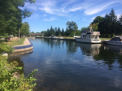
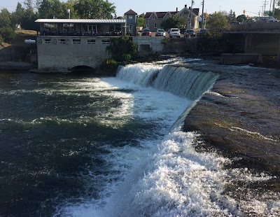
to dinner we walked to the other end of the lock where there is a viewing area
for the Fenelon Falls (photo at left), which are of course the reason for this
lock. There is also a small power generating station here, but it is out of
view on the right. Our destination for dinner was the building jutting out from
the shore just to the left of the ridge. The name of the restaurant is “The
Perch” so I had visions of a fresh perch dinner. To my great surprise the only
fish on the menu was cod in the fish ‘n chips. When I asked the waitress about
the lack of perch on the menu she quickly replied that the name refers to the
restaurant being “perched” above the falls. At that point I gave up and did not
bother to ask why the logo on the menu shows a blue heron holding what is
obviously a perch in its beak…
The downtown area (photo at right) had a
number of restaurants and many nice stores. In addition, we walked once about
0.8 miles to a Canadian Tire store only to find that it had already closed, but
we went back the next day on our bikes along with Lucky in her trailer towed
behind my bike. We were looking for one of the mid-sized floating swim pads.
They only had one of the huge ones left in stock so we will keep looking for
one about 6 feet square. At the far end of the lock wall was a nice park with a
small swimming area that Lucky liked to visit to drink the water.
On our full day in Fenelon
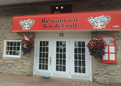
(Day 132) we went to the Dockside Bar and Grill (photo at left) for a nice
lunch of fish ‘n chips. In spite of its name it is across the street from the
lock and really has no view. Luckily I did not feel cheated by the name since
we went there specifically for the food and not the dockside view. Later we
went to dinner at the Bistro Thai Restaurant which was wonderful. I have been
having so much fish that the Thai food was a very pleasant change of pace.
One of our favorite food
establishments was also one of the closest to Lucky Us (photo at right). No, we
did not stop for ice cream every time that we passed by here, but they did have
our favorite Kawartha Ice Cream flavors. We have been enjoying this brand for
over a month as we have cruised down the Georgian Bay and along the Trent-Severn
Waterway. I started eating black cherry
ice cream way back in mid-June in the Door County area of Wisconsin, and I have
been having it ever since. However, my real favorite is the one made by
Kawartha!
So, we are probably two thousand road miles from home, and what do we find in Fenelon Falls? Yup, a genuine "Texas Burger"... Not exactly our favorite place to eat back home, but it did bring back some memories of home.
Subscribe to:
Posts (Atom)